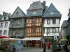
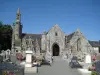
Plourac'h comes from the Breton "plou" meaning parish and primitive "rac'h" hill or escarpment. Church on a hill which rises to 227 meters.


Favourite


Plourac'h comes from the Breton "plou" meaning parish and primitive "rac'h" hill or escarpment. Church on a hill which rises to 227 meters.
| Municipality | Plourac'h |
|---|---|
| Postcode | 22160 |
| Latitude | 48.4171080 (N 48° 25’ 2”) |
| Longitude | -3.5476380 (W 3° 32’ 51”) |
| Altitude | From 125m to 284m |
| Surface area | 32.15 km² |
| Population | 332 inhabitants |
| Density | 10 inhabitants/km² |
| Prefecture | Saint-Brieuc (74 km, 1:05) |
| Insee code | 22231 |
| Intercommunality | CA Guingamp-Paimpol Agglomération de l'Armor à l'Argoat |
| Department | Côtes-d'Armor |
| Region | Brittany |
| Bolazec | 5.3 km (9 min) |
|---|---|
| Carnoët | 7 km (11 min) |
| Calanhel | 7.5 km (11 min) |
| Lohuec | 9.6 km (14 min) |
| Plusquellec | 10.8 km (15 min) |
| Callac | 11.9 km (15 min) |
| La Chapelle-Neuve | 12.9 km (17 min) |
| Scrignac | 13.4 km (21 min) |
| Guerlesquin | 13.8 km (21 min) |
| Duault | 13.9 km (20 min) |
| Poullaouen | 14.2 km (19 min) |
| Lannéanou | 15.8 km (22 min) |
| Plounévézel | 16.4 km (19 min) |
| Last name | Outing type | Difficulty | Duration | Departure municipality |
|---|---|---|---|---|
 | Hike | Intermediate | 3:05 | Bolazec (4.1 km) |
 | Hike | Easy | 55 min | Plougras (8.9 km) |
 | Hike | Intermediate | 2:35 | Loguivy-Plougras (9.6 km) |
 | Hike | Easy | 20 min | Loguivy-Plougras (9.6 km) |
 | Hike | Easy | 4:30 | Scrignac (9.8 km) |