


Favourite
Montmorillon
| Municipality | Adriers |
|---|---|
| Postcode | 86430 |
| Latitude | 46.2561810 (N 46° 15’ 22”) |
| Longitude | 0.7966670 (E 0° 47’ 48”) |
| Altitude | From 110m to 231m |
| Surface area | 68.09 km² |
| Population | 719 inhabitants |
| Density | 10 inhabitants/km² |
| Prefecture | Poitiers (59 km, 57 min) |
| Insee code | 86001 |
| Intercommunality | CC Vienne et Gartempe |
| Department | Vienne |
| Territory | Poitou |
| Region | New-Aquitaine |
| Mouterre-sur-Blourde | 7.9 km (12 min) |
|---|---|
| Nérignac | 7.9 km (11 min) |
| Moulismes | 10.2 km (12 min) |
| Moussac | 10.6 km (18 min) |
| L'Isle-Jourdain | 10.7 km (13 min) |
| Val-d'Oire-et-Gartempe | 11.1 km (12 min) |
| Luchapt | 11.7 km (17 min) |
| Plaisance | 13.5 km (16 min) |
| Persac | 13.6 km (18 min) |
| Asnières-sur-Blour | 13.8 km (21 min) |
| Le Vigeant | 14.3 km (19 min) |
| Millac | 15.5 km (18 min) |
| Lathus-Saint-Rémy | 16.9 km (21 min) |
| Queaux | 17.3 km (27 min) |
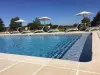
| Leisure centres | |
|---|---|
| Natural sites |
| Last name | Outing type | Difficulty | Duration | Departure municipality |
|---|---|---|---|---|
 | Hike | Intermediate | 3:55 | Mouterre-sur-Blourde (7 km) |
 | Car itinerary | Easy | 1:15 | L'Isle-Jourdain (8.9 km) |
 | Hike | Intermediate | 2:00 | L'Isle-Jourdain (8.9 km) |
 | Car itinerary | Easy | 1:05 | L'Isle-Jourdain (8.9 km) |
 | Hike | Easy | 3:35 | Lathus-Saint-Rémy (9.4 km) |