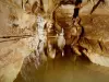
Located at 550 m altitude, 6 km from the cave of Mas d'Azil and equidistant from La Bastide-de-Seru.


Favourite
Located at 550 m altitude, 6 km from the cave of Mas d'Azil and equidistant from La Bastide-de-Seru.
| Municipality | Allières |
|---|---|
| Postcode | 09240 |
| Latitude | 43.0360800 (N 43° 2’ 10”) |
| Longitude | 1.3659250 (E 1° 21’ 57”) |
| Altitude | From 347m to 652m |
| Surface area | 9.10 km² |
| Population | 73 inhabitants |
| Density | 8 inhabitants/km² |
| Prefecture | Foix (25 km, 26 min) |
| Insee code | 09007 |
| Intercommunality | CC Couserans-Pyrénées |
| Department | Ariège |
| Territories | Midi-Pyrénées, Pyrenees |
| Region | Occitanie |
| Durban-sur-Arize | 4.4 km (11 min) |
|---|---|
| La Bastide-de-Sérou | 7.5 km (12 min) |
| Le Mas-d'Azil | 9.1 km (15 min) |
| Castelnau-Durban | 9.5 km (12 min) |
| Larbont | 9.7 km (15 min) |
| Suzan | 10.5 km (15 min) |
| Clermont | 10.9 km (14 min) |
| Montels | 11.2 km (15 min) |
| Nescus | 11.6 km (15 min) |
| Montseron | 11.6 km (15 min) |
| Sabarat | 12.9 km (20 min) |
| Camarade | 13.3 km (22 min) |
| Gabre | 14.1 km (21 min) |
| Rimont | 14.5 km (16 min) |
Festivities on the 3rd Sunday of July, the church square with mounjetado cooked over a wood fire (reservations recommended), bowls, super atmosphere.
| Last name | Outing type | Difficulty | Duration | Departure municipality |
|---|---|---|---|---|
 | Hike | Easy | 4:00 | La Bastide-de-Sérou (5.6 km) |
 | Hike | Easy | 3:00 | Ludiès (30 km) |
| Village visit | Intermediate | 2:00 | Carbonne (31 km) |
| Village visit | Easy | 4:00 | Galey (38 km) |
 | Mountain bike itinerary | Intermediate | 8:00 | Mirepoix (42 km) |