
Favourite
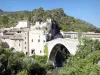
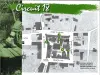
The Church of Sainte-Jalle


| Municipality | Arpavon |
|---|---|
| Postcode | 26110 |
| Latitude | 44.3702100 (N 44° 22’ 13”) |
| Longitude | 5.2674390 (E 5° 16’ 3”) |
| Altitude | From 341m to 1205m |
| Surface area | 13.45 km² |
| Population | 78 inhabitants |
| Density | 5 inhabitants/km² |
| Prefecture | Valence (114 km, 1:36) |
| Insee code | 26013 |
| Intercommunality | CC des Baronnies en Drôme Provençale |
| Department | Drôme |
| Territories | Dauphiné, Drôme-Ardèche |
| Region | Auvergne-Rhône-Alps |
| Curnier | 4.8 km (8 min) |
|---|---|
| Sainte-Jalle | 5.7 km (9 min) |
| Sahune | 9 km (13 min) |
| Les Pilles | 9 km (13 min) |
| Montaulieu | 9.7 km (19 min) |
| Condorcet | 9.9 km (15 min) |
| Rochebrune | 10.1 km (20 min) |
| Bésignan | 10.9 km (17 min) |
| Aubres | 11.5 km (15 min) |
| Le Poët-Sigillat | 11.7 km (21 min) |
| Eyroles | 11.8 km (18 min) |
| Saint-Sauveur-Gouvernet | 11.8 km (18 min) |
| Saint-Ferréol-Trente-Pas | 13 km (18 min) |
| Bellecombe-Tarendol | 14.3 km (22 min) |


| Last name | Activity type | Rate | City |
|---|---|---|---|
 | Nature and the great outdoors | 15 € | Rousset-les-Vignes (17.5 km) |
 | Local flavours | Free | Sault (31 km) |
 | Well-being | Free | Sault (32 km) |
 | Local flavours | 15 € | Pont-de-Barret (33 km) |
 | Sports sensations | 45 € to 55 € | Mormoiron (34 km) |
| Last name | Outing type | Difficulty | Duration | Departure municipality |
|---|---|---|---|---|
 | Hike | Easy | 1:30 | Nyons (10.2 km) |
 | Hike | Easy | 2:00 | Richerenches (28 km) |
 | Village visit | Easy | 40 min | Richerenches (28 km) |
 | Cycling itinerary | Easy | 1:00 | Richerenches (28 km) |
 | Hike | Easy | 2:00 | Gigondas (30 km) |