


Favourite
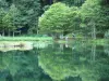
Bethmale lake
| Municipality | Arrout |
|---|---|
| Postcode | 09800 |
| Latitude | 42.9450050 (N 42° 56’ 42”) |
| Longitude | 1.0274550 (E 1° 1’ 39”) |
| Altitude | From 480m to 959m |
| Surface area | 3.02 km² |
| Population | 94 inhabitants |
| Density | 31 inhabitants/km² |
| Prefecture | Foix (57 km, 59 min) |
| Insee code | 09018 |
| Intercommunality | CC Couserans-Pyrénées |
| Department | Ariège |
| Territories | Midi-Pyrénées, Pyrenees |
| Region | Occitanie |
| Cescau | 2.9 km (7 min) |
|---|---|
| Audressein | 3.3 km (6 min) |
| Castillon-en-Couserans | 3.8 km (8 min) |
| Engomer | 4.3 km (8 min) |
| Sor | 5.3 km (9 min) |
| Balaguères | 6 km (15 min) |
| Bordes-Uchentein | 6 km (10 min) |
| Argein | 6.2 km (9 min) |
| Salsein | 6.8 km (13 min) |
| Moulis | 7.4 km (10 min) |
| Arrien-en-Bethmale | 7.9 km (14 min) |
| Aucazein | 8 km (12 min) |
| Illartein | 8.6 km (11 min) |
| Villeneuve | 10.2 km (29 min) |
| Last name | Activity type | Rate | City |
|---|---|---|---|
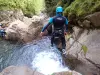 | Sports sensations | 35 € to 60 € | Bagnères-de-Luchon (39 km) |
| Last name | Outing type | Difficulty | Duration | Departure municipality |
|---|---|---|---|---|
 | Village visit | Easy | 4:00 | Galey (9.2 km) |
 | Hike | Easy | 4:00 | La Bastide-de-Sérou (33 km) |
| Village visit | Intermediate | 2:00 | Carbonne (42 km) |
 | Hike | Intermediate | 3:00 | Bize (46 km) |
 | Cycling itinerary | Athletic | 5:45 | Arreau (54 km) |