


Favourite
Cognac
| Municipality | Authon-Ébéon |
|---|---|
| Postcode | 17770 |
| Latitude | 45.8333348 (N 45° 50’ 0”) |
| Longitude | -0.3999990 (W 0° 23’ 60”) |
| Altitude | From 16m to 36m |
| Surface area | 11.65 km² |
| Population | 395 inhabitants |
| Density | 33 inhabitants/km² |
| Prefecture | La Rochelle (86 km, 1:20) |
| Insee code | 17026 |
| Intercommunality | CC Vals de Saintonge Communauté |
| Department | Charente-Maritime |
| Territory | Charentes |
| Region | New-Aquitaine |
| Aujac | 3.1 km (7 min) |
|---|---|
| Migron | 4.7 km (8 min) |
| Courcerac | 5.3 km (10 min) |
| Bercloux | 5.4 km (7 min) |
| Aumagne | 5.4 km (10 min) |
| Villars-les-Bois | 5.7 km (11 min) |
| Prignac | 7.8 km (15 min) |
| Mons | 7.8 km (13 min) |
| Brizambourg | 7.8 km (12 min) |
| Le Seure | 8.1 km (13 min) |
| La Brousse | 8.4 km (17 min) |
| Sainte-Même | 8.8 km (13 min) |
| Blanzac-lès-Matha | 9 km (17 min) |
| Mesnac | 9.1 km (14 min) |
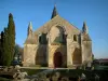
| Monuments |
|---|
| Last name | Activity type | Rate | City |
|---|---|---|---|
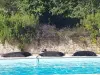
 | Sports sensations | 10 € to 20 € | Saint-Bris-des-Bois (8.5 km) |
 | Local flavours | Free | Graves-Saint-Amant (32 km) |
 | Sports sensations | 275 € | Marennes-Hiers-Brouage (45 km) |
 | Entertainment | 40 € | Saint-Sulpice-de-Royan (50 km) |
| Last name | Outing type | Difficulty | Duration | Departure municipality |
|---|---|---|---|---|
 | Hike | Easy | 1:05 | Saintes (20 km) |
 | Hike | Easy | 4:05 | Saintes (21 km) |
 | Hike | Easy | 3:45 | Puyrolland (30 km) |
 | Hike | Easy | 1:00 | Mons (31 km) |
| Village visit | Easy | 1:00 | Le Gua (44 km) |