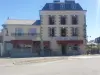

Favourite
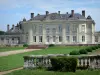
Craon Castle
| Municipality | Ballots |
|---|---|
| Postcode | 53350 |
| Latitude | 47.8954809 (N 47° 53’ 44”) |
| Longitude | -1.0505220 (W 1° 3’ 2”) |
| Altitude | From 48m to 93m |
| Surface area | 36.01 km² |
| Population | 1337 inhabitants |
| Density | 37 inhabitants/km² |
| Prefecture | Laval (31 km, 36 min) |
| Insee code | 53018 |
| Intercommunality | CC du Pays de Craon |
| Department | Mayenne |
| Territory | Maine |
| Region | Pays de la Loire |
| La Roë | 4.5 km (3 min) |
|---|---|
| Laubrières | 5.8 km (5 min) |
| La Selle-Craonnaise | 6.5 km (8 min) |
| Saint-Michel-de-la-Roë | 6.6 km (6 min) |
| Niafles | 7.9 km (9 min) |
| Gastines | 8 km (8 min) |
| Fontaine-Couverte | 8.5 km (9 min) |
| Livré-la-Touche | 9.3 km (12 min) |
| Craon | 9.3 km (10 min) |
| Saint-Poix | 10.1 km (11 min) |
| Athée | 10.1 km (13 min) |
| Cuillé | 10.3 km (11 min) |
| Méral | 10.5 km (14 min) |
| Saint-Aignan-sur-Roë | 11.4 km (12 min) |
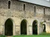
| Monuments | |
|---|---|
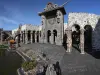
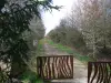
| Natural sites |
| Last name | Outing type | Difficulty | Duration | Departure municipality |
|---|---|---|---|---|
 | Hike | Easy | 1:45 | Prée-d'Anjou (18.2 km) |
 | Village visit | Easy | 2:00 | La Roche-Neuville (25 km) |
 | Hike | Intermediate | 3:00 | Piré-Chancé (31 km) |
 | Cycling itinerary | Easy | 1:15 | Rougé (32 km) |
 | Hike | Intermediate | 2:45 | Châteaugiron (37 km) |