Liven up your holidays!

Frédéric-Fontaine

Tourism, holidays & weekends guide in the Haute-Saône

Frédéric-Fontaine - Tourism, holidays & weekends guide in the Haute-Saône
7.3
3

Geographical information

MunicipalityFrédéric-Fontaine
Postcode70200
Tourism label
Latitude47.6567409 (N 47° 39’ 24”)
Longitude6.6289160 (E 6° 37’ 44”)
AltitudeFrom 334m to 498m
Surface area3.48 km²
Population267 inhabitants
Density76 inhabitants/km²
PrefectureVesoul (45 km, 42 min)
Insee code70254
IntercommunalityCC Rahin et Chérimont
DepartmentHaute-Saône
TerritoryFranche-Comté
RegionBurgundy-Franche-Comté

Nearest cities & towns

Clairegoutte1.5 km (3 min)
Magny-Jobert3.1 km (9 min)
Magny-Danigon3.6 km (7 min)
Andornay4.3 km (7 min)
Palante5.2 km (9 min)
Lomont5.4 km (7 min)
Étobon6.4 km (15 min)
Ronchamp6.5 km (10 min)
Lyoffans6.6 km (8 min)
Belverne6.7 km (8 min)
La Côte7.1 km (12 min)
Courmont7.2 km (11 min)
Faymont8.6 km (13 min)
Moffans-et-Vacheresse10.4 km (16 min)
Champagney10.5 km (16 min)

Things to see and do

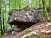
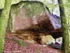
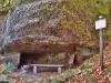
The rock of the Saracens.

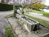
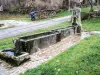
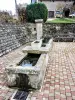
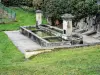
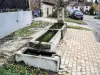
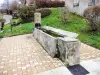
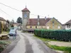
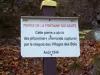
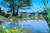
The eight fountains-lavoirs including the fountain of the Prince.

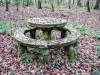
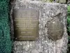
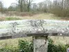
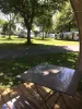
The table of the Statuary.

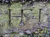
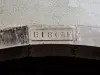
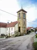
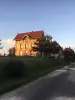
The curious bell tower of the temple with its clock dial carved in stone.

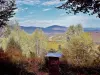
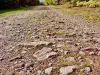
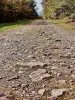
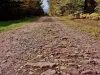
See the remaining section of the old Roman road, on the heights of Chérimont.

Places of interest

Natural sites

Photos

The ponds of the village (© J.E)
See photo
Frédéric-Fontaine, seen from the Champs de la Bêche road (© J.E)
See photo
Prince's Fountain (© J.E)
See photo
Rock of the Saracens (© J.E)
See photo
Fountain at the bottom of the village (© J.E)
See photo
The table of the Statuary (© J.E)
See photo
The well of the Statuary (© J.E)
See photo
The temple-town-school (© J.E)
See photo
Lintel spanner dated 1840 (© J.E)
See photo
Fountain in the bottom of the village (© J.E)
See photo
Fountain in the top of the village (© J.E)
See photo
Prince's Fountain (© J.E)
See photo
Fontaine-lavoir, in the center of the village (© J.E)
See photo
Fontaine-lavoir, at the top of the village (© J.E)
See photo
Fontaine-lavoir, at the top of the village (© J.E)
See photo
Frédéric-Fontaine, seen from the Champs de la Bêche road (© J.E)
See photo
Rock of the Saracens (© J.E)
See photo
Rock of the Saracens (© J.E)
See photo
Henri-Frédéric Iselin's initials on his stone bench (© J.E)
See photo
The table of the Statuary (© J.E)
See photo
The temple-town-school, seen from behind (© J.E)
See photo
Lintel dated 1863 (© J.E)
See photo
The temple-town-school (© J.E)
See photo
Village quadricentenary souvenir plate (© J.E)
See photo
Belvedere of the white rock, overlooking Ronchamp - GR 59 (© J.E)
See photo
A section of the old Roman road, on the heights of Chérimont (© J.E)
See photo
A section of the old Roman road, on the heights of Chérimont (© J.E)
See photo
Rock of the fountain jumping (© J.E)
See photo
A section of the old Roman road, on the heights of Chérimont (© J.E)
See photo
Indications on the rock of the fountain jumping (© J.E)
See photo

Weather

Monday 20 may
Min. 8°C - Max. 22°C
Day
Night
Tuesday 21 may
Min. 12°C - Max. 15°C
Day
Night
Wednesday 22 may
Min. 12°C - Max. 13°C
Day
Night

Visits, leisure and activities nearby

Many opportunities for hiking.

Leisure activities

Last nameActivity typeRateCity
Visit a copper mine
Culture and education11 € Le Thillot (26 km)
Interactive tour of a leather studio
Arts and Crafts12 € Basse-sur-le-Rupt (39 km)

Outings

Last nameOuting typeDifficultyDurationDeparture municipality
Walk to Fort Lachaux- Grand-Charmont, Sochaux, Montbéliard
HikeIntermediate35 minGrand-Charmont (21 km)
Tour of the lake
HikeEasy1:00Sewen (27 km)
Lachtelweiher Lake
HikeIntermediate2:30Kirchberg (29 km)
Tour of the historic centre
Village visitEasy1:00Masevaux-Niederbruck (30 km)
3 lakes circuit
HikeIntermediate4:40Rimbach-près-Masevaux (31 km)

Restaurants

Bed & breakfasts

Vacation rentals

Campsites

Hotels

Your holidays
A hotel
A vacation rental
A bed & breakfast
A campsite
A leisure activity
A restaurant
A rental car
A plane ticket
By continuing to browse our site, you are agreeing to the use of cookies to improve your experience and make targeted offers.
Find out more and make settings
Your account