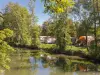
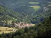
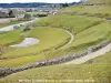
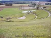
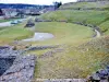
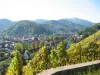
Mandeure is located on a loop of the Doubs, an ideal geographical location which explains the establishment, in Roman times, of the city of Epomanduodurum.

Favourite


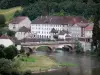
Mandeure is located on a loop of the Doubs, an ideal geographical location which explains the establishment, in Roman times, of the city of Epomanduodurum.
| Municipality | Mandeure |
|---|---|
| Postcode | 25350 |
| Tourism label | ") |
| Latitude | 47.4502200 (N 47° 27’ 1”) |
| Longitude | 6.8094200 (E 6° 48’ 34”) |
| Altitude | From 324m to 581m |
| Surface area | 15.13 km² |
| Population | 4945 inhabitants |
| Density | 326 inhabitants/km² |
| Prefecture | Besançon (79 km, 55 min) |
| Insee code | 25367 |
| Intercommunality | CA Pays de Montbéliard Agglomération |
| Department | Doubs |
| Territories | Franche-Comté, Jura mountains |
| Region | Burgundy-Franche-Comté |
| Mathay | 3.7 km (6 min) |
|---|---|
| Valentigney | 4.1 km (7 min) |
| Seloncourt | 5.8 km (12 min) |
| Écurcey | 5.9 km (10 min) |
| Bondeval | 6.1 km (10 min) |
| Audincourt | 6.5 km (11 min) |
| Voujeaucourt | 6.6 km (10 min) |
| Bourguignon | 7 km (10 min) |
| Autechaux-Roide | 8.1 km (15 min) |
| Berche | 8.9 km (14 min) |
| Bart | 8.9 km (15 min) |
| Taillecourt | 9 km (14 min) |
| Hérimoncourt | 9 km (15 min) |
| Dampierre-sur-le-Doubs | 9.1 km (15 min) |
| Exincourt | 9.3 km (15 min) |
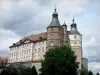
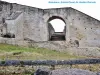
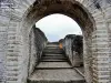
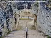
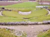
| Monuments |
|---|

| Last name | Activity type | Rate | City |
|---|---|---|---|
 | Culture and education | 11 € | Le Thillot (47 km) |
| Last name | Outing type | Difficulty | Duration | Departure municipality |
|---|---|---|---|---|
 | Hike | Intermediate | 35 min | Grand-Charmont (7.8 km) |
 | Hike | Easy | 1:00 | Pays-de-Clerval (24 km) |
 | Village visit | Easy | 1:00 | Masevaux-Niederbruck (39 km) |
 | Hike | Intermediate | 3:00 | Masevaux-Niederbruck (39 km) |
 | Hike | Intermediate | 1:00 | Burnhaupt-le-Haut (40 km) |