Liven up your holidays!

Nivigne et Suran

Tourism, holidays & weekends guide in the Ain

Nivigne et Suran - Tourism, holidays & weekends guide in the Ain
8.0
3

Chavannes-sur-Suran:

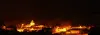
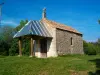
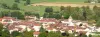
Chavannes-sur-Suran is located 18 km from Bourg-en-Bresse, via the Col de France. This village is located on the road from Neuville-sur-Ain to Montfleur and Lons-le-Saunier. It is bathed by the only river crossing the Revermont from North to South, Suran.

This quiet valley has a very busy past made of many battles, fires, wars.

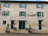
Old fortified city, this village has kept many vestiges of the time when it kept the border between the County of Burgundy and the Duchy of Savoy then the Kingdom of France.

Germagnat:

Germagnat is located on the road from Neuville-sur-Ain to Orgelet, this town is bordering the department of Jura.

Germagnat is bounded on the south by the ancient village of Arnans, the village of Chavannes-sur-Suran in the Suran valley and on the Nivigne mountain.

To the west, the village of Germagnat is bounded by the Nivigne ridge, the hamlet of Dalles in the commune of Pouillat, and the ridge of Montpetit hill.

In the north, Germagnat is surrounded by the Monts de Germagnat, and the shores of Sapinet and the "On the Knight", on which were still recently two bollards planted in 1555.

To the east, the chain of Bouvans and Renardières surround Germagnat, as well as the village of Aromas in the Jura.

Geographical information

MunicipalityNivigne et Suran
Postcode01250
Tourism label
Latitude46.2643650 (N 46° 15’ 52”)
Longitude5.4267810 (E 5° 25’ 36”)
AltitudeFrom 306m to 770m
Surface area30.98 km²
Population861 inhabitants
Density27 inhabitants/km²
PrefectureBourg-en-Bresse (19.9 km, 26 min)
Insee code01095
IntercommunalityCA du Bassin de Bourg-en-Bresse
DepartmentAin
TerritoriesAlps, Jura mountains
RegionAuvergne-Rhône-Alps

Nearest cities & towns

Simandre-sur-Suran4.6 km (6 min)
Pouillat7.8 km (10 min)
Montfleur7.8 km (8 min)
Aromas8.4 km (12 min)
Val-Revermont8.9 km (13 min)
Grand-Corent9.1 km (13 min)
Drom9.8 km (14 min)
Corveissiat9.9 km (12 min)
Villereversure10.2 km (13 min)
Jasseron11.2 km (14 min)
Broissia11.5 km (12 min)
Meillonnas11.8 km (16 min)
Cize12.7 km (19 min)
Charnod13.3 km (19 min)
Ramasse13.6 km (20 min)

Things to see and do

Chavannes-sur-Suran:
Germagnat:

Places of interest

Monuments

Events and festivities

Chavannes-sur-Suran:

Photos

General view of the village of Chavannes-sur-Suran
See photo
Church of Chavannes-sur-Suran
See photo
Heritage Land
Heritage Land
See photo
Suran
Suran
See photo
The Revermont
The Revermont
See photo
Path above the village of Chavannes-sur-Suran
See photo
Path above the village of Chavannes-sur-Suran in winter
See photo
Heart of the village of Chavannes-sur-Suran in winter
See photo
The entrance of Chavannes-sur-Suran in winter
See photo
Chavannes-sur-Suran by night
See photo

Weather

Monday 20 may
Min. 9°C - Max. 22°C
Day
Night
Tuesday 21 may
Min. 13°C - Max. 14°C
Day
Night
Wednesday 22 may
Min. 12°C - Max. 14°C
Day
Night

Visits, leisure and activities nearby

Leisure activities

Last nameActivity typeRateCity
Motocross, trial or enduro lessons
Sports sensations37 € Joudes (23 km)
Canyoning or Via Ferrata in Jura with Eskaléo
Sports sensations40 € to 65 € Saint-Claude (36 km)
Canyoning around Saint-Claude
Sports sensations45 € Saint-Claude (37 km)
Canyoning in Jura
Sports sensations45 € to 55 € Clairvaux-les-Lacs (43 km)
Dramatised tour: Medieval immersion in Pérouges
Culture and education36 € Pérouges (44 km)

Outings

Last nameOuting typeDifficultyDurationDeparture municipality
Walk The waterfall Pisse Cow
HikeEasy40 minMatafelon-Granges (6.4 km)
Hiking at Balvay Castle
HikeIntermediate4:45Bolozon (8.9 km)
Hiking the Two Valleys
HikeIntermediate4:15Matafelon-Granges (10.1 km)
Hiking The Tour of the Oignin
HikeIntermediate2:25Samognat (10.4 km)
Condamine circuit (around Izernore)
HikeEasy3:00Izernore (11.1 km)

Restaurants

Bed & breakfasts

Vacation rentals

Campsites

Hotels

Your holidays
A hotel
A vacation rental
A bed & breakfast
A campsite
A leisure activity
A restaurant
A rental car
A plane ticket
By continuing to browse our site, you are agreeing to the use of cookies to improve your experience and make targeted offers.
Find out more and make settings
Your account