Liven up your holidays!

Pleurtuit

Tourism, holidays & weekends guide in the Ille-et-Vilaine

Pleurtuit - Tourism, holidays & weekends guide in the Ille-et-Vilaine
8.8
6

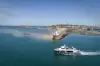
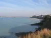
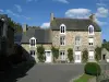
The common Pleurtuit is framed by two rivers, the Frémur to the west and east Rance. The estuary of the Rance a width of 1 km in height Pleurtuit looks like rivers of Brittany which dates back the tide. Formerly many mills operated by the energy of the sea Guard, Moulin Neuf Montmarin.

The Rance estuary is marked by remarkable sites: the tip of Cancaval (instead of walk), the castle Montmarin (built in the eighteenth), the loop of Montmarin. To access the Rance three blocks exist: Montmarin, Jouvente Poriou.

Pleurtuit experienced during the second war, the greatest loss of human history and was declared a disaster to 80%. For all its sacrifices, the town was awarded the Croix de Guerre.

Geographical information

MunicipalityPleurtuit
Postcode35730
Tourism label
Latitude48.5796200 (N 48° 34’ 47”)
Longitude-2.0591560 (W 2° 3’ 33”)
Surface area29.67 km²
Population7085 inhabitants
Density238 inhabitants/km²
PrefectureRennes (72 km, 54 min)
Insee code35228
IntercommunalityCC Côte d'Émeraude
DepartmentIlle-et-Vilaine
RegionBrittany

Nearest cities & towns

Tréméreuc2.5 km (4 min)
Le Minihic-sur-Rance4.4 km (8 min)
La Richardais5.4 km (9 min)
Pleslin-Trigavou5.7 km (9 min)
Dinard6.1 km (9 min)
Langrolay-sur-Rance6.7 km (10 min)
Beaussais-sur-Mer7.6 km (9 min)
Plouër-sur-Rance8.9 km (10 min)
Saint-Briac-sur-Mer8.9 km (11 min)
Saint-Lunaire9 km (12 min)
Lancieux10.7 km (15 min)
Languenan11.8 km (16 min)
Saint-Jacut-de-la-Mer13.6 km (17 min)

Things to see and do

In the interior of the existing water mills, but most were destroyed during the catastrophic floods of 1929 are the homes of milling mills to Girls, Val, of Pomphily, Guard, Dick's, Pont Touraud, of the Lock.

Former manor fortified battlements retain some such manor Pomphily and city Boterel or remains more important as the firm Castle Pontbriand, destroyed during the revolution.

The steeple of the church built in 1880 amounted to 62 meters above the ground, 130 meters above the sea served as a landmark for sailors returning from Newfoundland. In 1941, the occupying authority flush the tower to its current level is 22 meters. The wrought iron cross surmounting the tower is erected near the church.

Places of interest

Leisure centres
Monuments
Performance halls
Transport

Events and festivities

Photos

Pointe de Cancaval
Pointe de Cancaval
See photo
Place du Général de Gaulle
See photo
Cale du Montmarin
Cale du Montmarin
See photo
Le Bois Joli
Le Bois Joli
See photo
The Town Hall
The Town Hall
See photo
The church
The church
See photo
The town
The town
See photo
The town
The town
See photo
The town
The town
See photo
The commune
The commune
See photo
The commune
The commune
See photo
The commune
The commune
See photo
The church
The church
See photo
Interior of the church
See photo
Fountain
Fountain
See photo

Weather

Friday 31 may
Min. 12°C - Max. 17°C
Day
Night
Saturday 1 june
Min. 12°C - Max. 16°C
Day
Night
Sunday 2 june
Min. 11°C - Max. 18°C
Day
Night

Visits, leisure and activities nearby

Leisure activities

Last nameActivity typeRateCity
Dinard Saint-Malo crossing on a Vedette boat
Nature and the great outdoors8 € Dinard (6 km)
Private cruise from Pointe du Grouin to Cap Fréhel
Nature and the great outdoors160 € to 400 € Saint-Malo (6.5 km)
Cruise with commentary in the Bay of Saint-Malo
Culture and education23 € Saint-Malo (7.8 km)
Segway ride to explore Saint-Malo in a different way
Entertainment29 € to 168 € Saint-Malo (8.4 km)
Visit an exhibition and sale at artists' studios
Arts and CraftsFreeDol-de-Bretagne (23 km)

Outings

Last nameOuting typeDifficultyDurationDeparture municipality
Beach Bridge to the beach in Le Havre Lupin
HikeEasy2:00Saint-Malo (8.1 km)
Saint-Jacut's grand tour
HikeIntermediate5:35Saint-Jacut-de-la-Mer (9.8 km)
In the footsteps of the Romans in mountain biking
Mountain bike itineraryAthletic2:55Corseul (14 km)
Loop Matignon - ​​Saint-Pôtan - Ruca
All-terrain bike itineraryEasy1:10Matignon (17.2 km)
On the steps of the quarrymen
HikeIntermediate1:15Fréhel (24 km)

Restaurants

Bed & breakfasts

Vacation rentals

Campsites

Hotels

Your holidays
A hotel
A vacation rental
A bed & breakfast
A campsite
A leisure activity
A restaurant
A rental car
A plane ticket
By continuing to browse our site, you are agreeing to the use of cookies to improve your experience and make targeted offers.
Find out more and make settings
Your account