Saint-Étienne-de-Saint-Geoirs is a town in the Isere region Auvergne-Rhône-Alpes, 40 km northwest of Grenoble.
Its territory of 18 square kilometers belongs to the plain of Bièvre, dominated to the east by the Chartreuse mountains.
Already occupied by the Romans in ancient times, the town develops in the Middle Ages. It is equipped with fortifications because of its strategic location and arouses desires to attachment of the Dauphine to the kingdom of France in 1349.
In agricultural activity are added in the nineteenth century textile units active until the second half of the twentieth century and a factory of skis. These industries disappeared, the economy of the town is now driven by the direct and indirect activity related to implantation north of the town from the airport of Grenoble-Alpes Isère arranged for the 1968 Winter Olympics. it serves the regional capital, Grenoble, but also ski resorts in the season.
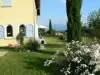
birthplace of smuggler Mandrin eighteenth century Saint-Étienne-de-Saint-Geoirs which has about 3300 inhabitants preserved a heritage interest. With its protected environment (east south of the town) and leisure offer, it makes a pleasant stop.
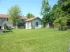
If the locality has developed in recent decades to the north with commercial areas and activities close to the airport, the old town has retained a real character and heritage elements of interest.
This is the case of remains of ramparts in the Middle Ages that ran along a canal fed by a ditch. Current Mill streets, the Reach and Wash house have been built over the centuries on the route of the ramparts.
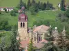
In the historic center, a Heritage Discovery shaped walk can include high St. Stephen's Church in 1864 with typical materials of the region (pebbles and bricks). The bell tower and a manor chapel of the fifteenth are the only preserved elements of the original church which was destroyed during the Wars of Religion.
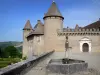
Strong home Fassion (fifteenth and seventeenth) who once commanded the entrance "south" of the village, which belonged a time to the family of the composer Berlioz, the stronghold of Saint-candle (XV, rebuilt in the nineteenth century), also called château Saint-candle, the tower of the old castle Dauphin (referring to the Dauphin John II, lord of the Dauphiné) are also observed. As of course the birthplace of legendary smuggler Mandrin and that of his mother, the strong house Varanin, fourteenth and remodeled in the nineteenth century, who commanded the gate called Grenoble.
Featuring a highly distinctive character, the old town is lined with old houses in pebbles, a still visible architectural technique at the Big Slide, a path rollers connecting the town to the old castle.
More recent, the halls to metal structures built in 1889 complete this survey.
In terms of sports then "nature", tennis fans can book a court from the local club (Contact 04 76 65 52 or 06 38 March 11 91 22). In the summer the communal swimming pool is ready for its part to swimming but also to relax. Opened in July and August except Tuesday. Information +33 4 76 65 46 62 or +33 4 76 65 40 35.
It is obviously necessary to mention the Grenoble-Alpes-Isère Airport. In addition to commercial traffic with nearly 400 000 passengers per year and several regular lines (information on +33 4 76 65 48 48), are based on the site different clubs and associations. This is the case of the flying club Grenoble and its region (first flights, tourist flights: information +33 7 86 51 39 83), the flying club of Dauphine (flight school: Contact the +33 4 74 84 65 17) and a parachute school (information on +33 4 74 54 71 57).
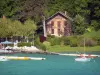
The locality environment finally will delight hikers and areas of rich biodiversity. On the pond site Chanclau, east of the village, a journey of discovery of the fauna and local flora has been laid, dotted with educational signs. The area is also managed by a bird protection association that has created a refuge.
Marked trails are also marked on the east and south of the territory, between woods and ponds. They gauge the typical landscape of the Plain of Bièvre which Berlioz said: "Gold and green, his silence indescribable majesty dreamy, further enhanced by the belt of mountains terminal behind which stand the gigantic peaks Alpes."
Maps and information +33 4 76 65 40 35 or +33 4 76 36 25 86.
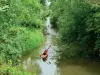
Fishermen are also invited to enjoy the rivers and lakes. Two associations are established on the common: information +33 4 76 93 54 47 or +33 4 76 35 28 18.
")