

Favourite
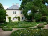
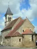
Orsan Priory Gardens
| Municipality | Saint-Hilaire-en-Lignières |
|---|---|
| Postcode | 18160 |
| Latitude | 46.7273200 (N 46° 43’ 38”) |
| Longitude | 2.1741570 (E 2° 10’ 27”) |
| Altitude | From 159m to 268m |
| Surface area | 53.78 km² |
| Population | 497 inhabitants |
| Density | 9 inhabitants/km² |
| Prefecture | Bourges (49 km, 52 min) |
| Insee code | 18216 |
| Intercommunality | CC Berry Grand Sud |
| Department | Cher |
| Territory | Berry |
| Region | Centre-Loire Valley |
| Lignières | 3.6 km (7 min) |
|---|---|
| Touchay | 6.3 km (11 min) |
| Rezay | 6.7 km (10 min) |
| Saint-Christophe-en-Boucherie | 7.2 km (7 min) |
| La Celle-Condé | 8.3 km (13 min) |
| Ids-Saint-Roch | 11.2 km (14 min) |
| Maisonnais | 11.3 km (13 min) |
| La Berthenoux | 12.7 km (15 min) |
| Vicq-Exemplet | 13.3 km (17 min) |
| Chezal-Benoît | 13.4 km (15 min) |
| Ineuil | 13.4 km (17 min) |
| Thevet-Saint-Julien | 13.6 km (12 min) |
| Le Châtelet | 13.8 km (17 min) |
| Saint-Baudel | 14.4 km (22 min) |
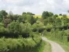
| Natural sites |
|---|
| Last name | Activity type | Rate | City |
|---|---|---|---|
 | Entertainment | 75 € to 120 € | Issoudun (28 km) |
| Last name | Outing type | Difficulty | Duration | Departure municipality |
|---|---|---|---|---|
 | Hike | Easy | 3:00 | Moutier-Malcard (41 km) |
 | Hike | Easy | 2:00 | Quincy (45 km) |
 | Village visit | Easy | 1:00 | Hérisson (48 km) |