Liven up your holidays!

Spicheren

Tourism, holidays & weekends guide in the Moselle

On top of its 300 meters, the village overlooks Spicheren, first west of the basin Warndt crossed by roads and railways that connect Metz Germany via Forbach, and secondly to the north, its larger neighbor, the city of Saarbrücken, capital of the Saarland with which it shares a border of 4.350 kilometers.

The battle of the Franco-Prussian August 6th, 1870 transformed the heights in Spicheren historic site strewn with memorials, the most impressive is the great cross of French memory.

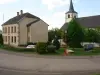
The district of Bremen Golden, located at the foot of the mountain Spicheren, straddling the RN3 and the A320 motorway, has significantly expanded after the war for 1939/45 today after 800 residents, after was until 1993 a border post between the very important France and Germany.

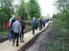
Rich is the historical heritage of the town, is also its rich natural heritage. Landscape diversity is remarkable: a valley horseshoe enclosing a tray with very fertile land, all dominated south by a limestone ridge rising to 357 m, occupied largely by a quarry of limestone in the first half of the 20th century, declared today a voluntary nature reserve where you can admire, among others, several varieties of wild orchids. The 150 hectares of forests that surround the village, is crossed by numerous roads and trails border: hikers, bikers, joggers or walkers simple, everyone can find his account until specialist fauna and flora rich and diverse without forget the reception area converted into cross-border educational forest on the hills.

Geographical information

MunicipalitySpicheren
Postcode57350
Tourism label
Latitude49.1948320 (N 49° 11’ 41”)
Longitude6.9706980 (E 6° 58’ 15”)
AltitudeFrom 220m to 357m
Surface area8.11 km²
Population3283 inhabitants
Density404 inhabitants/km²
PrefectureMetz (67 km, 48 min)
Insee code57659
IntercommunalityCA de Forbach Porte de France
DepartmentMoselle
TerritoryLorraine
RegionGreat East

Nearest cities & towns

Alsting3.6 km (14 min)
Etzling3.6 km (7 min)
Kerbach4.9 km (10 min)
Behren-lès-Forbach5.1 km (9 min)
Stiring-Wendel5.4 km (10 min)
Schoeneck7.1 km (13 min)
Grosbliederstroff7.1 km (11 min)
oeting7.3 km (12 min)
Bousbach7.6 km (12 min)
Forbach8.2 km (16 min)
Lixing-lès-Rouhling9.1 km (14 min)
Folkling9.4 km (18 min)
Tenteling10.5 km (17 min)
Nousseviller-Saint-Nabor10.6 km (16 min)
Théding12.4 km (22 min)

Weather

Friday 31 may
Min. 11°C - Max. 16°C
Day
Night
Saturday 1 june
Min. 11°C - Max. 15°C
Day
Night
Sunday 2 june
Min. 14°C - Max. 19°C
Day
Night

Visits, leisure and activities nearby

Outings

Last nameOuting typeDifficultyDurationDeparture municipality
Cycle path following the route of an old railway line
Cycling itineraryEasy4:30Frauenberg (13.1 km)
Tour of Escherbruch Lake
HikeEasy30 minHam-sous-Varsberg (24 km)
Border path
HikeEasy2:00Berviller-en-Moselle (25 km)
Along the Eichel
Cycling itineraryEasy4:00Lorentzen (31 km)
Heritage of Alsace Bossue
HikeEasy2:00Diemeringen (32 km)

Restaurants

Bed & breakfasts

Vacation rentals

Hotels

Your holidays
A hotel
A vacation rental
A bed & breakfast
A campsite
A leisure activity
A restaurant
A rental car
A plane ticket
By continuing to browse our site, you are agreeing to the use of cookies to improve your experience and make targeted offers.
Find out more and make settings
Your account