Paths galvachers former carters Morvan

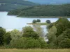
Settons Lake


Paths galvachers former carters Morvan
| Department | Saône-et-Loire |
|---|---|
| Departure municipality | Anost |
| Outing type | Village visit |
| Difficulty | Athletic |
| Duration | 4:00 |
| Recommended period | from january to december |
| Kilometres | 12 km |
| Altitude upon departure | 470m |
| Change in altitude | 560m |
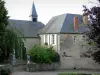
The starting point is the old village hall.
Since the current town hall, up the main street about 150 meters. The old town hall is 150 meters on the right.
Departure town
Take the D2 to the north, to 10 m and turn left towards the Grelodots. At the cross turn left and follow the path straight up the road.
Cross the bridge, turn right and take the left path that is common to the GR13 (red and white markings) and GRP (red and yellow). Follow the road about 2 km to Bussy.
At the entrance of the village, turn left, cross the road and go straight the ridge path (PR: yellow signs and GR13 red and white). Walk about 600 m are 3 beacons (GR13 GRP + PR +), then turn droire, to 10 m and turn right again. Stay on the right path for 300 meters to reach the D388 road. Turn left and follow the D388 for 1.2 km. Arrived at Athez, turn left towards the C6 calved. Roll on the wooden bridge and turn right. Attention face 3 paths take the middle and browse 300 m before turning left (GR13 is exited and returns to the GRP). Make 1.4 km, to find the C6. Turn right and reach the chapel calved (we leave the GRP). Bypassing the left and turn right. Make 150 m and turn left. We leave the road and follow a dirt road. Continue straight ahead and after 300 meters turn left and follow the path until Sanceray.
Reached the white cross, turn left and to 250 m before turning right. At the paved road go straight to the intersection of the C10 and Bonnards. Turn left and follow the path until you cross the D2. Take the paved road in front for a return to the starting point.
Back hall