
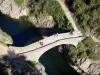
Departure of the "INFO RANDO" sign, Place du Champ de Mars. Join the RN 102 and walk along it with caution, left for about 200m. Take the path under the Apic Bridge on the left. Built in 1762, during the drilling of the national road, the bridge was built with stones carved by a single man and assembled without binding. Continue down along the basaltic flow. In La Roche, follow the "Fargebelle, Jaujac" sign. Join the road and follow it to the right to the end. Go down to the left and cross the Devil's Bridge. After the bridge, follow the path to the left for about 20m and engage right on the path that goes up into the chestnut grove. On the way up, very nice perspective on the Giant's Causeway, Thueyts and the Devil's Bridge. Continue in the undergrowth, pass the small stone bridge and walk along the abandoned hamlet of Fragebelle, dating back to the 14th century. Be careful, it is forbidden to enter the hamlet. In Fargebelle, follow the sign "Thueyts". Walk down the "cemented" track for about 50m and then take a left of the path that crosses the chestnut trees and moors. Pass through the rocks, wade through the creek and pass a crumbling barn to reach the Coustet des Vernèdes. At the Coustet des Vernèdes, follow the sign "Thueyts, Queen's Scale". Go down to the track and cross the bridge over the Ardèche. Walk along the property and climb the 213 steps of the Queen's ladder. At the top, continue along the path lined with two walls, join the hamlet of Tramontel and then RN 102. In Fargebelle, follow the "INFO RANDO" sign. Cross RN 102 with caution and to the fountain, take Gaschet Street and find the Place du Champs de Mars.
Thueyts