(D / A) Start walking out of the parking and taking left the marked yellow path. Turn right at the campground entrance and stage. The trail is paved for 200 meters and then gives way to a dirt path then branches off to the left. Continue on the path dotted with plaques "Saint-Estèphe circuit" until the Yellow directional sign "loop Malibas".
(1) Turn right and follow this direction marked resulting in a small paved road. Follow the signs by taking this road on the left and take the first road to the left at the entrance of the hamlet of Chevalarias. Cross the hamlet of Mérigaud and go straight to reach the crossroads of the main road D91E3.
(2) At the junction of this road is a yellow directional sign "loop and loop Malibas Fixard". Follow this direction by taking opposite a small asphalt road gives way to a path and leads to Badeix.
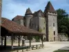
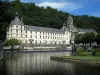
(3) Take a break at this crossroads to turn his gaze on a long building that is on the left. This is the Badeix priory monks of the grandmontines. The church that is left of the monastery buildings was shortened in the seventeenth century. Resume hiking and turn left to go outside the entrance of the priory is private. Continue on the road two hundred meters and then leave the markup and take a small road on the right that will lead, after a hundred and fifty meters, on a road that is to be taken also on the right. On the secondary portion that follows, leave the right road to Fixard and continue to the next crossing.
(4) Turn right and take a signposted path Yellow indicated by a small sign "menhir". The menhir is 100 meters; this is one of the few standing stones of Périgord, authenticated by the curator of the museum of Geneva. It is dated between 5000 and 2000 BC. Continue the marked yellow path to a paved road. Turn left following the signs to the hamlet of Fixard.
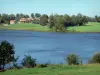
(5) At the exit of turn two, turn right at the yellow trail always signposted. At two small ponds, turn right on the path that will then make a left elbow at 90 °. Keep right and then the following two branches, the first houses, turn right again.
Take the second right and turn immediately left at the fork that follows.
(6) 150 meters before reaching the D91, leaving the Yellow markup that starts right and then left onto the county. Turn right on the latter then 80 m further turn right on a path carrying a yellow markings and a white and red markings (GR). Back down to the sports complex and follow the GR to the tower Piégut.
(7) To start the site, track twice markup and turn into a small alley that is located to the right of the exit. Turn right onto Rue Jean Petit and again right at the fork following to borrow the old Roman road. Leave left access to a pond and continue on the path that is more hooks and eventually lead to a road near the hamlet of Bridarias. On this portion represents more than two kilometers, the remains of a Roman road are present in the beginning.
(8) Follow the road to the left and leave the double-tagging and take the first right. Continue to the hamlet of Chevalarias.
(9) In the first group of houses on the left, leave the road and turn left a paved road passable. Across the way, is a large building with white shutters with a well. This paved road makes only a hundred meters. By the time he turns hairpin, turn left on a path that has a positive slope at the start and that remains ridgeline until the wooden bridge that passes over the marshy part of the large pond and joined the Saint-Estèphe parking Camping (D / A).
At the end of tour, you have the opportunity to tour the pond. For this, do not pass the wooden footbridge that goes over the marshy part of the pond, but take the path along the pond on your left until tray 6 places. Take it and follow the path along the edge of the pond to the beach and beach bars to resume the path along the edge of the pond that takes you back to the parking lot. The tower is 3 km.