Liven up your holidays!

Hiking the chapel of Mornay

Hikes & walks in Nurieux-Volognat

Hiking the chapel of Mornay - Hikes & walks in Nurieux-Volognat
8.3
6

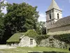
This hiking marked out in yellow starts at the exit of the village of Nurieux. The path then goes up a forest path to Mornay. A round trip is recommended to the chapel Saint Pierre located at the top of the "Pointu". From there, we can see the cluse and Lake Nantua. The path continues between forest and meadows until the "bottleneck", then down to Volognat to join Nurieux. Topo guide on sale at the Tourist Office of Izernore and Monts Berthiand
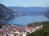
Description sheet

DepartmentAin
Departure municipalityNurieux-Volognat
Outing typeHike
DifficultyEasy
Duration2:35
Kilometres7 km
Altitude upon departure485m
Change in altitude315m

Access

Depart from the town of Nurieux-Volognat, latitude 46.1809600 (N 46° 10’ 51”), longitude 5.5216200 (E 5° 31’ 18”)

Itinerary

Visit ideas nearby

By continuing to browse our site, you are agreeing to the use of cookies to improve your experience and make targeted offers.
Find out more and make settings
Your account