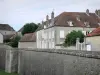
Start: Place de Champigny-les-Langres - Signposting: yellow and yellow - Walking time: 5h - Duration mountain bike: 2h30 - Difficult level - From the place of Champigny-lès-Langres, down the alley of the Dîme, then take on the left, rue du Moulinot. Turn right to reach the canal passing under the railway. Arrived on the towpath, take a right again and follow it to the lock Jorquenay. Change bank to reach the center of the village and its turning bridge. Cross the canal on the latter and take the strategic road n ° 5 opposite; be careful, it's climbing hard! Once up an area, picnic allows you to make a well deserved halt, while admiring one of the most beautiful views of the city of Langres. Continue to follow the strategic route through the Rocherie Woods to the road. Then turn right towards Lannes and join the village until the Departmental No. 121. Continue straight ahead to go up to the church (picnic area). Walk along the north side of the church and take the path on the right that will take you to the Val de la Coudre stream, which you have to cross over the footbridge. At the first crossroads, turn left 300 m, then again left at the calvary. After 1 km on a grassy path, you arrive on the D 262. Then turn right to join Charmes. Arriving on the D 121 in the center of the village, turn left 50 m then right, towards Jorquenay. At 50 m, turn left on a small country road that will take you to the lake dam Charmes. Continue your route along this beautiful valley, passing under the railway and along the locality of the "Saussey" until the strategic n ° 4. Then take a right, in the direction of Champigny-lès-Langres, leave aside the first path on your left to enter the second. After 50 m, take a right fork to enter a grass path along a fence: you are then on the old Roman road from Langres to Trier that you have to follow to the water tower. Then turn right to reach your starting point in Champigny-lès-Langres. All the tourist info on
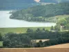
The Land of Four Lakes