Visit Rabuons Lake with its very varied mineral world at an altitude of 2,500 m, which offers a unique panoramic view over the entire Upper Tinée region!

The ski resorts of Alpes-Maritimes
Visit Rabuons Lake with its very varied mineral world at an altitude of 2,500 m, which offers a unique panoramic view over the entire Upper Tinée region!

| Department | Alpes-Maritimes |
|---|---|
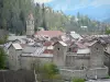
| Departure municipality | Saint-Étienne-de-Tinée |
| Outing type | Village visit |
| Difficulty | Athletic |
| Duration | 7:00 |
| Recommended period | from july to september |
| Environment | Mountains |
| Kilometres | 14 km |
| Altitude upon departure | 1140m |
| Change in altitude | 1400m |
Park at the Mercantour car park in the village of Saint-Étienne-de-Tinée and start at marker 100 after the bridge on the way out of the village towards the Bonette Pass.
A steep climb above the village of Saint-Étienne-de-Tinée through a forest of hazel and spruce. Walk up to the Chemin de l'Energie at marker 103. Continue to marker 104 and one last push to the refuge and Rabuons Lake. Stop off at the refuge for a slice of blueberry tart and admire the magnificent landscape. Return via the same route.