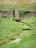
Well shaded forest walk with viewpoints.
Épinal


Well shaded forest walk with viewpoints.

| Department | Vosges |
|---|---|
| Departure municipality | Épinal |
| Outing type | Hike |
| Difficulty | Easy |
| Duration | 3:00 |
| Recommended period | from april to october |
| Environment | Countryside |
| Kilometres | 12 km |
| Change in altitude | 300m |
From the centre of Épinal, take the D434 towards Xertigny. Turn right at the second set of traffic lights after the Casino supermarket. Pass under a railway bridge and make your way to a small car park with an information board, which is where the circuit starts.
From the car park, take Rue de la Devallée signposted with a green dot and a red triangle which climbs up to the supply canal for Bouzey Lake. Turn right on to the right bank along the canal.
Cross the bridge, turn right on to Chemin des Murgères, and through the forest for 150 m, then turn left on to the path signposted with a red triangle only called the "circuit des coteaux de Saint-Laurent".
Rest at the top of the climb and admire the natural beauty of this forest which offers a mixture of deciduous and resinous trees. Continue along a cliff top path with views over the Etranglieux valley and the old village of Vieux Saint-Laurent.
The path signposted with a red triangle only follows a forest road for a while before turning left to join the hamlet of Les Murgères 600 m further on. Walk 20 m down the road and then turn left on to the path which is now signposted with a green dot.
Slightly further on, you will arrive at a pasture, at the far end of which you have to turn right and enter the forest again. Cross a small tarmac road and follow a fenced field. The dirt track signposted with a green dot will follow almost a straight path to Bult Lake (1). You have reached the mid-point of the itinerary.
At the entrance to the lake, turn right on to the path indicated Bertraménil, Riéfaing, Humbertois, Bouffrot. Follow the lake and enter a magnificent beech forest which, after a clearing in the forest, arrives at Riéfaing Lake (2).
At the bottom of the slope, turn left and follow the green dot signposting along the lake, slightly above it. Just afterwards, you will arrive a stone path which leads to Humbertois Farm (3) outside of which you should turn right on to the small tarmac road. Continue along it for 200 m and turn left on to the Bouffrot forest road in Épinal Forest.
Continue to follow the signposting (green dot) towards Bouffrot and Bertraménil. You will arrive at the foot of the old quarry, which you should walk around along a path leading upwards on the left. When you arrive at the top, continue along the ridge trail which leads to the site of the Bouffrot Rocks (4). Slightly lower down, you will arrive at a forest path which you should cross to turn right on to the supply canal for Bouzey Lake, following the green dot signposting. After crossing a bridge, turn right and cross a siphon with stairs.
Follow the canal again on the left. 40 m further on, stop and, on the right, look at the remarkable rock in the mound called the Salière du Loup (5). Following the canal, 700 m further on you will find the tarmac road you started out on which will lead down to the car park.