1. Behind the church, exit the meadow and follow the marked path to the school car park. At the road, turn right. Follow it to Theil.
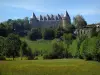
2. Go around the EDF post and turn left onto the path which runs alongside a fence, follow this path which winds between the meadows. At the castle of Soumagnas (private), turn right onto the wide path and follow it until the small road.
3. Turn left onto the RD110. Enter the village of La Thiverie, taking the first road on the left, follow it to the cross. Fork to the left, at the exit of the village. Follow the path to the Buisson farm. Cross the farm and follow the road to the RD110.
# Take a short return trip to the Gallo-Roman washhouse by taking the first small road on the right at the entrance to the village.
4. Turn left 30 m further on, take the path to the right in the forest. Follow it until the small road and turn left.
5. 40 m further on, turn left into the path in the forest. At the end, turn right through the meadows to the RD699 and the hamlet of Troque-Fer.
# Variant: at the road turn right, repeat the description at point 7.
6. Cross the RD, take the Mas Buisson road opposite. On leaving the village, follow the path up to the road.
7. Take this one to the left for 15 m then follow the path to the left until the "Y" junction of the paths.
8. Leave the path on the right and follow the one that goes slightly to the left. The path becomes stony before reaching the road. Cross it, take the path opposite in the moor, then to the right the path which leads to the village of Massaloux. Take the winding road opposite.
9. In the bend, take the path furthest to the right which goes into the woods and descends towards the Massaloux stream. Cross it and continue to the road. Take it to the right, then at the crossroads (cross), take the road to the left. Just before the hamlet, turn left and find the road downhill. Take it on the right.
# Connection: the dirt track on the right in the wood leads to the paths of Pageas.
Continue on the road, pass the Peyrat-de-Massaloux, the bridge and go up. Go back through Massaloux and take the path in the opposite direction to the crossroads of "Y" paths (point 8).
8. Take the path that goes slightly to the left. At the RD59, turn right and 30 m further on, turn right again towards Montlouis. Take the path that goes to the left between the houses, follow it. Cross the road and go opposite.
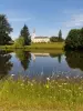
10. At La Chatonette, take the dirt track that goes down into the forest. Cross the RD699, and 20 m to the left, descend the steps and find yourself at the edge of the Gorre fishing pond.
To the shortest: bypass on the left and join the starting point at the church.
Otherwise, go around on the right and stop at the educational pond halfway around the pond, and reach the starting point at the church.
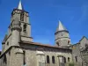
The reliquary cross is presented in the church, the keys are available at the town hall during opening hours.