Liven up your holidays!

Aiglun

Tourism, holidays & weekends guide in the Alpes-Maritimes

Aiglun - Tourism, holidays & weekends guide in the Alpes-Maritimes
9.0
7

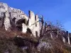
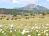
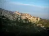
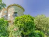
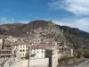
Village, nestled on the slopes of Mont Saint-Martin, built sheer above the Estéron. Aiglun contemplate the mountain of Cheiron. Its tall old houses are nestled around the town hall and parish church of Saint-Raphael (XVIII) decorated with a double front turret. This small village is built on top of a cliff overlooking the River Estéron. It is surrounded by wilderness and mountains and faces the imposing Cheiron. Beautiful old houses lining the narrow streets and gathering around the church and town hall.

The inhabitants are called the "aiglenois" legacy of the 13th century, a period of great prosperity, which appears Aiglun name or Aiglesunum Aigledunum.

Passed to the Duchy of Savoy in 1388, border Mas, Aiglun finally joined the Kingdom of France in the Treaty of 1760.

Origin of soils: secondary formations (Jurassic / Cretaceous).

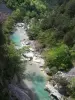
The municipality is part of the geographical area of ​​the Alps in Grasse. Mountain, it is crossed from east to west by the river Estéron, a tributary of the Var, in the north of the village, she dug a clue to a depth of 200-400 m, 2 km long between the Mountains and Saint Charamel Martin. Clustered on a rocky south-facing, the village is protected from prevailing winds by the Mont Saint Martin, stands opposite the north slope of Mount Cheiron (1607 m).

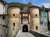
The architecture is already experiencing a Provencal influence alpine, the houses are high, tight against each other, equipped with ventilated attics. The hostel communal spanning the quiet country road by an imposing vaulted porch, is characteristic of most mountain architecture of the village cluster.

Frédéric Mistral celebrated charm Aiglun in "Calendal". All these landscapes inspired Frederic Mistral in his book "Calendal" published in 1867, where he celebrates the charm of Aiglun.

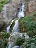
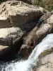
Caption: "hell hole" ... Saint Martin, bishop of Tours, lived for a time as a hermit on top of the mountain overlooking Aiglun. Every day that God was doing, he had to go down to the river, some 600 meters down to drink his ass. Imagined the devil to tempt by a spring in a cave near the Hermitage. Insensitive to the temptation and evil, the holy man managed to lock up the devil in the cave, it can not escape by digging a passage in the rock: the Devil's Hole.

Geographical information

MunicipalityAiglun
Postcode06910
Latitude43.8576350 (N 43° 51’ 27”)
Longitude6.9146370 (E 6° 54’ 53”)
AltitudeFrom 373m to 1541m
Surface area15.37 km²
Population93 inhabitants
Density6 inhabitants/km²
PrefectureNice (68 km, 1:15)
Insee code06001
IntercommunalityCC Alpes d'Azur
DepartmentAlpes-Maritimes
TerritoriesAlps, French Riviera
RegionProvence-Alps-French Riviera

Nearest cities & towns

Le Mas8.5 km (14 min)
Sigale9.6 km (18 min)
Roquestéron11.1 km (19 min)
La Roque-en-Provence11.9 km (21 min)
Cuébris12.7 km (22 min)
Saint-Pierre17.9 km (28 min)
Sallagriffon19.1 km (32 min)
Saint-Antonin19.5 km (34 min)
La Penne20 km (31 min)
Conségudes22 km (37 min)
La Rochette22 km (37 min)
Collongues23 km (36 min)
Les Mujouls24 km (39 min)
Saint-Auban25 km (37 min)

Things to see and do

Clue of Aiglun.

Places for walks: The rural chapels of St. Raphael and St. Joseph, the cascade of Vegay, the old bridge with its view, the troglodyte fortress.

Activities: Canyoning (April to October) - Climbing - Via Ferrata. Information +33 6 78 54 26 73.

Places of interest

Natural sites

Events and festivities

In May: Feast of St Joseph Vascogne.

In July: Feast of St. Raphael (the last weekend of July).

Mid-August: Provençal day.

August: The Summer of the General Council.

Photos

Clue to Aiglun
Clue to Aiglun
See photo
Village Aiglun from the perspective of the Snows Gréolières
See photo
Clue to Aiglun
Clue to Aiglun
See photo
Bridge over the Estéron
See photo
Auberge Communal
Auberge Communal
See photo
Village Aiglun
Village Aiglun
See photo
Cascade Vegay
Cascade Vegay
See photo

Weather

Monday 20 may
Min. 8°C - Max. 18°C
Day
Night
Tuesday 21 may
Min. 11°C - Max. 19°C
Day
Night
Wednesday 22 may
Min. 11°C - Max. 19°C
Day
Night

Visits, leisure and activities nearby

Leisure activities

Last nameActivity typeRateCity
Canyoning in the Gours du Ray – Departing from Gréolières (40 mins. From Grasse)
Sports sensations55 € Gréolières (7.3 km)
Paragliding over the Préalpes d'Azur Regional Natural Park
Sports sensations90 € to 130 € Gréolières (7.3 km)
Sportive Canoe Rafting on your own on the Var River – 1 hour from Nice
Sports sensations30 € Villars-sur-Var (15.7 km)
River Hiking in the Loup Gorges – Departing from Gourdon (40 mins from Grasse)
Sports sensations45 € Gourdon (16.2 km)
Rock Climbing in the Loup Gorges – Departing from Gourdon (40 mins. From Grasse)
Sports sensations55 € Gourdon (16.2 km)

Outings

Last nameOuting typeDifficultyDurationDeparture municipality
The Cheiron Itinerary
HikeAthletic5:00Gréolières (7.3 km)
Les Miroirs hike
HikeEasy2:45Gréolières (7.3 km)
Heritage itinerary
Village visitEasy1:30Gréolières (7.3 km)
Peak of the Eagle
HikeIntermediate3:30Thorenc (10.6 km)
Collettes Peak
HikeIntermediate3:30Toudon (16.7 km)

Restaurants

Bed & breakfasts

Vacation rentals

Campsites

Hotels

Your holidays
A hotel
A vacation rental
A bed & breakfast
A campsite
A leisure activity
A restaurant
A rental car
A plane ticket
By continuing to browse our site, you are agreeing to the use of cookies to improve your experience and make targeted offers.
Find out more and make settings
Your account