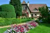
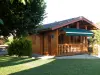
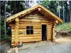
See Alsatian houses beautifully maintained.


Favourite


| Municipality | Ballersdorf |
|---|---|
| Postcode | 68210 |
| Tourism label | ") |
| Latitude | 47.6230480 (N 47° 37’ 23”) |
| Longitude | 7.1611200 (E 7° 9’ 40”) |
| Altitude | From 292m to 387m |
| Surface area | 10.72 km² |
| Population | 829 inhabitants |
| Density | 77 inhabitants/km² |
| Prefecture | Colmar (69 km, 54 min) |
| Insee code | 68017 |
| Intercommunality | CC Sud Alsace Largue |
| Department | Haut-Rhin |
| Territory | Alsace |
| Region | Great East |
| Gommersdorf | 3.3 km (6 min) |
|---|---|
| Dannemarie | 3.4 km (5 min) |
| Fulleren | 4 km (7 min) |
| Mertzen | 5.4 km (9 min) |
| Manspach | 5.5 km (7 min) |
| Retzwiller | 5.5 km (8 min) |
| Wolfersdorf | 5.8 km (8 min) |
| Carspach | 6.5 km (8 min) |
| Strueth | 6.8 km (11 min) |
| Hagenbach | 6.9 km (9 min) |
| Altenach | 7 km (9 min) |
| Traubach-le-Bas | 7.2 km (10 min) |
| Elbach | 7.4 km (12 min) |
| Aspach | 7.8 km (10 min) |
| Altkirch | 7.9 km (12 min) |
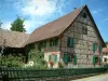
See Alsatian houses beautifully maintained.


| Last name | Activity type | Rate | City |
|---|---|---|---|
 | Culture and education | 11 € | Le Thillot (41 km) |
| Last name | Outing type | Difficulty | Duration | Departure municipality |
|---|---|---|---|---|
 | Hike | Intermediate | 1:00 | Burnhaupt-le-Haut (11.9 km) |
 | Village visit | Easy | 1:00 | Masevaux-Niederbruck (21 km) |
 | Hike | Intermediate | 3:00 | Masevaux-Niederbruck (21 km) |
 | Hike | Intermediate | 1:05 | Thann (21 km) |
 | Hike | Intermediate | 2:30 | Kirchberg (25 km) |