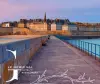
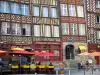
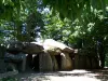
Favourite
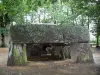
Roche-aux-Fées

| Municipality | Essé |
|---|---|
| Postcode | 35150 |
| Latitude | 47.9579070 (N 47° 57’ 28”) |
| Longitude | -1.4230860 (W 1° 25’ 23”) |
| Altitude | From 32m to 92m |
| Surface area | 23.19 km² |
| Population | 1071 inhabitants |
| Density | 46 inhabitants/km² |
| Prefecture | Rennes (33 km, 40 min) |
| Insee code | 35108 |
| Intercommunality | CC Roche aux Fées Communauté |
| Department | Ille-et-Vilaine |
| Region | Brittany |
| Boistrudan | 3.8 km (7 min) |
|---|---|
| Le Theil-de-Bretagne | 4.7 km (8 min) |
| Marcillé-Robert | 5.3 km (8 min) |
| Janzé | 6.4 km (9 min) |
| Retiers | 6.8 km (10 min) |
| Moulins | 8.4 km (12 min) |
| Piré-Chancé | 8.7 km (13 min) |
| Coësmes | 9.1 km (13 min) |
| Visseiche | 9.7 km (13 min) |
| Brie | 9.9 km (14 min) |
| Sainte-Colombe | 10.3 km (15 min) |
| Amanlis | 12.5 km (14 min) |
| Arbrissel | 12.6 km (15 min) |
| Monuments |
|---|
| Last name | Outing type | Difficulty | Duration | Departure municipality |
|---|---|---|---|---|
 | Hike | Intermediate | 3:00 | Piré-Chancé (5.3 km) |
 | Hike | Intermediate | 2:45 | Châteaugiron (11.5 km) |
 | All-terrain bike itinerary | Intermediate | 2:05 | Châteaugiron (11.6 km) |
 | All-terrain bike itinerary | Intermediate | 2:05 | Châteaugiron (11.8 km) |
 | All-terrain bike itinerary | Athletic | 2:15 | Vern-sur-Seiche (16.4 km) |