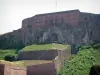
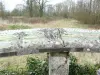
Panorama from the foot of the tower Florimont.


Favourite


| Municipality | Florimont |
|---|---|
| Postcode | 90100 |
| Tourism label | ") |
| Latitude | 47.5095130 (N 47° 30’ 34”) |
| Longitude | 7.0688960 (E 7° 4’ 8”) |
| Altitude | From 367m to 505m |
| Surface area | 18.19 km² |
| Population | 455 inhabitants |
| Density | 25 inhabitants/km² |
| Prefecture | Belfort (31 km, 33 min) |
| Insee code | 90046 |
| Intercommunality | CC du Sud Territoire |
| Department | Territoire de Belfort |
| Territory | Franche-Comté |
| Region | Burgundy-Franche-Comté |
| Courtelevant | 1.3 km (4 min) |
|---|---|
| Courcelles | 1.8 km (4 min) |
| Faverois | 3.5 km (5 min) |
| Réchésy | 4.5 km (7 min) |
| Lepuix-Neuf | 4.9 km (9 min) |
| Delle | 5.9 km (10 min) |
| Joncherey | 6.2 km (10 min) |
| Thiancourt | 7.4 km (11 min) |
| Suarce | 8 km (12 min) |
| Pfetterhouse | 9.1 km (14 min) |
| Grandvillars | 9.1 km (13 min) |
| Lebetain | 9.1 km (16 min) |
| Ueberstrass | 9.2 km (12 min) |
| Friesen | 9.4 km (15 min) |
| Seppois-le-Bas | 9.5 km (11 min) |
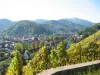
Panorama from the foot of the tower Florimont.


| Last name | Activity type | Rate | City |
|---|---|---|---|
 | Culture and education | 11 € | Le Thillot (47 km) |
| Last name | Outing type | Difficulty | Duration | Departure municipality |
|---|---|---|---|---|
 | Hike | Intermediate | 35 min | Grand-Charmont (18.5 km) |
 | Hike | Intermediate | 1:00 | Burnhaupt-le-Haut (25 km) |
 | Village visit | Easy | 1:00 | Masevaux-Niederbruck (30 km) |
 | Hike | Intermediate | 3:00 | Masevaux-Niederbruck (30 km) |
 | Hike | Intermediate | 2:30 | Kirchberg (33 km) |