Liven up your holidays!

Hérimoncourt

Tourism, holidays & weekends guide in the Doubs

Hérimoncourt - Tourism, holidays & weekends guide in the Doubs
8.4
2

Geographical information

MunicipalityHérimoncourt
Postcode25310
Tourism label
Latitude47.4419440 (N 47° 26’ 31”)
Longitude6.8821670 (E 6° 52’ 56”)
AltitudeFrom 350m to 578m
Surface area7.29 km²
Population3672 inhabitants
Density503 inhabitants/km²
PrefectureBesançon (87 km, 1:08)
Insee code25304
IntercommunalityCA Pays de Montbéliard Agglomération
DepartmentDoubs
TerritoriesFranche-Comté, Jura mountains
RegionBurgundy-Franche-Comté

Nearest cities & towns

Seloncourt3.2 km (6 min)
Meslières3.3 km (6 min)
Thulay3.4 km (6 min)
Vandoncourt4.5 km (7 min)
Glay4.6 km (7 min)
Abbévillers5 km (7 min)
Roches-lès-Blamont5.6 km (10 min)
Bondeval5.7 km (11 min)
Audincourt5.9 km (11 min)
Valentigney6.1 km (12 min)
Dasle6.2 km (12 min)
Montbouton6.3 km (11 min)
Dannemarie7 km (13 min)
Beaucourt7.6 km (13 min)
Écurcey8.4 km (14 min)

Things to see and do

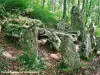
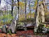
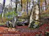
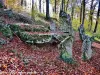
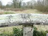
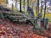
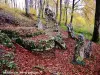
Visit the amazing megalithic site called Gallic stones.

Places of interest

Leisure centres
Monuments

Photos

Church of St. Peter and St. Paul (© J.E)
See photo
Rue Rolland Commander (© J.E)
See photo
Old fountain, near the temple (© J.E)
See photo
Stones Gallic - megalithic site (© J.E)
See photo
Fountain in front of the church (© J.E)
See photo
Mayor of Hérimoncourt (© J.E)
See photo
Church of St. Peter and St. Paul (© J.E)
See photo
forest Autumn colors (© J.E)
See photo
Sunrise on the (false) menhir (© J.E)
See photo
Celtic Stones (© JE)
See photo
Megalithic site (© J.E)
See photo
Stones Gallic - megalithic site (© J.E)
See photo
Megalithic site (© J.E)
See photo
Megalithic site (© J.E)
See photo
Megalithic site (© J.E)
See photo
Cartridge, dated 1797 (© J.E)
See photo
Cartridge, dated 1865 (© J.E)
See photo
Cartridge, dated 1879 (© J.E)
See photo
Key lintel dated 1776 (© J.E)
See photo
Church of St. Peter and St. Paul (© J.E)
See photo
Rue Rolland Commander (© J.E)
See photo
Lutheran Church of Hérimoncourt (© J.E)
See photo
Lutheran Church of Hérimoncourt (© J.E)
See photo

Weather

Friday 24 may
Min. 7°C - Max. 14°C
Day
Night
Saturday 25 may
Min. 8°C - Max. 17°C
Day
Night
Sunday 26 may
Min. 10°C - Max. 20°C
Day
Night

Visits, leisure and activities nearby

Leisure activities

Last nameActivity typeRateCity
Visit a copper mine
Culture and education11 € Le Thillot (49 km)

Outings

Last nameOuting typeDifficultyDurationDeparture municipality
Walk to Fort Lachaux- Grand-Charmont, Sochaux, Montbéliard
HikeIntermediate35 minGrand-Charmont (9.7 km)
Reposoir Chapel
HikeEasy1:00Pays-de-Clerval (29 km)
Rangen massif
HikeIntermediate1:00Burnhaupt-le-Haut (38 km)
Tour of the historic centre
Village visitEasy1:00Masevaux-Niederbruck (38 km)
Sattelboden Chalet
HikeIntermediate3:00Masevaux-Niederbruck (38 km)

Restaurants

Bed & breakfasts

Vacation rentals

Campsites

Hotels

Your holidays
A hotel
A vacation rental
A bed & breakfast
A campsite
A leisure activity
A restaurant
A rental car
A plane ticket
By continuing to browse our site, you are agreeing to the use of cookies to improve your experience and make targeted offers.
Find out more and make settings
Your account