The Ferrière:
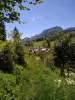
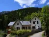
A small village in Auvergne-Rhône-Alpes, La Ferrière is located in the department of Isère, in the heart of the Haut Bréda valley. It is located about fifty kilometers from Grenoble, not far from Arvillard, Détrier and Allevard. Crossed by the Breda, it is appreciated for its slopes covered with forests and its spaces dedicated to ski touring and cross-country skiing in winter.
The Ferrière is illustrated in the eleventh century by the exploitation of its iron deposits. Independent until the mid-nineteenth century despite its location on the border of Savoy, it has over the centuries experienced a slow and steady decline of its population until today. Long known for its iron work, the Isère city has now turned to tourism with a very important economic activity of relaxation and recreation, especially thanks to its winter sports resort.
The Ferrière:
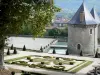
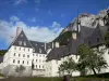
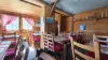
As you walk through the village, you will appreciate the traditional mountain architecture, including the Saint-Maximin church of the 19th century. Do not miss to admire the barn of Epinay of the seventeenth century labeled Heritage in Isère, or the remains of the border between France and the Duchy of Savoy including the two coats of arms located at the neck of the Cross.
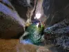
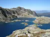
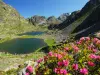
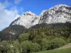
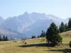
The Ferrière has six protected natural areas that it is possible to discover the time of marked hiking. You will appreciate the beauty of the Tigneux mountain, the moors of the Oudis pass, the Sept-Laux peat bogs, the Gleysin mountain, the eastern slopes of the Sept-Laux massif or the western side of the Villards valley.
Also worthy of interest, the Col de la Croix, Lake Cos, Lake Carré, Rock Arguille, Lake Motte or the rock of Argentiere, worth a stop to admire the grandeur of the landscapes.
The village of La Ferrière also has a winter sports area, that of Sept-Laux, which includes the stations of Prapoutel, Pipay and Pleynet. It is dedicated to cross-country skiing and downhill skiing, also allowing the practice of hiking, mountain biking or horseback riding in the summer.
Pinsot:
The Forges and Mills of Pinsot: The mills of the eighteenth century flour and walnut oil that work with the hydraulic power of the torrent were put back into service as well as the forge, the cutting and its swift.
The Iron Trail Pinsot: Located at an average altitude of 990 meters, this trail allows you to discover the remains of the ancient mining of iron ore furnaces, slag, tunnel entrances, ruins of shelters of minor and houses. Throughout this route, historical and technical information is presented on desks and cast iron plates of 400 kg each. Panorama on the Gleyzin massif in the Belledonne range. The cross near the hamlet of Ayettes indicates one of the three accesses to the iron path. The elevation from this point to the Jeu de Paume is 400 meters.
")