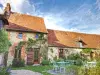
A statue of St Eloi is in the church built in the 16th century. The nave and tower date from 1977.


Favourite
| Municipality | Le Mesnil-Conteville |
|---|---|
| Postcode | 60210 |
| Latitude | 49.6685919 (N 49° 40’ 7”) |
| Longitude | 2.0585660 (E 2° 3’ 31”) |
| Altitude | From 115m to 179m |
| Surface area | 3.49 km² |
| Population | 75 inhabitants |
| Density | 21 inhabitants/km² |
| Prefecture | Beauvais (34 km, 39 min) |
| Insee code | 60397 |
| Intercommunality | CC de la Picardie Verte |
| Department | Oise |
| Territory | Picardy |
| Region | Hauts-de-France |
| Beaudéduit | 1.8 km (3 min) |
|---|---|
| Lavacquerie | 3.7 km (7 min) |
| Conteville | 3.9 km (7 min) |
| Thoix | 4.7 km (12 min) |
| Laverrière | 4.9 km (11 min) |
| Sommereux | 5.7 km (8 min) |
| Choqueuse-les-Bénards | 5.8 km (9 min) |
| Offoy | 6.5 km (14 min) |
| Belleuse | 6.8 km (9 min) |
| Hétomesnil | 7 km (12 min) |
| Cempuis | 7.5 km (11 min) |
| Catheux | 8.8 km (13 min) |
| Le Hamel | 8.8 km (13 min) |
| Fontaine-Bonneleau | 9 km (13 min) |
A statue of St Eloi is in the church built in the 16th century. The nave and tower date from 1977.
| Last name | Outing type | Difficulty | Duration | Departure municipality |
|---|---|---|---|---|
 | Hike | Easy | 3:00 | Courcelles-sous-Moyencourt (16 km) |
| Hike | Intermediate | 4:00 | Courcelles-sous-Moyencourt (16 km) |
 | Hike | Easy | 2:00 | Paillart (21 km) |
 | Village visit | Easy | 2:00 | Saint-Maulvis (31 km) |
 | Hike | Easy | 50 min | Gournay-en-Bray (32 km) |