Magné is a commune in Deux-Sèvres, in the Nouvelle-Aquitaine region, to the south-west of Niort with which it borders.
Its territory of 14.8 km² has the specificity of being surrounded by arms of the Sèvre Niortaise, forming an island which is accessed by five bridges.
The landscapes remain green there, with more than 75% of agricultural land and some still wooded areas.
Inhabited by the Gauls and then the Romans, the village was formed at the turn of the year 1000 with the construction of a tower to prevent the Norman invasions, which later turned into a fortified castle. This will unfortunately be insufficient, however, during the Wars of Religion which saw the locality being plundered by the Protestants.
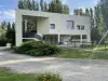
In the 19th century, the pottery industry and sawmills developed. Activities of which there are still some testimonies, but since the Second World War, Magné has benefited above all from the growth of the Niort area and highlights its environment (Poitevin marsh) which appeals to green tourism enthusiasts. The town, which has nearly 2,700 inhabitants, has a high-quality cultural and "nature" leisure offer.
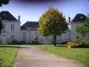
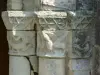
Once in the heart of the town, in other words after having taken one of the five bridges leading to Magné, the visitor can very quickly discover the first notable heritage element of the town: the parish church of Saint Catherine. It dates from 1521, after the wife of the local lord, Catherine de Coëtiviy, also niece of the King of France, founded a chapter of six canons. As for the tenth century building dedicated to Saint-Germain d'Auxerre, it had already been destroyed for a long time. Looted by the Huguenots, transformed into a warehouse and then into a military hospital after the Revolution, the church was restored in the 19th century and then entered in the Inventory. At the architectural level, we observe that the building ends with a straight apse pierced with a large glass roof, and a gable adorned with an imposing rose window. The interior, for its part, has four bays covered with groin vaults and flanked, on the right and left, by barrel sections framed by buttresses. The sculpted decorations are in the Renaissance style. The church houses an 18th century canvas representing "the Virgin swaddling the child Jesus", an altarpiece at the level of the chapel of the Blessed Sacrament and stained glass windows from the 19th and 20th centuries.
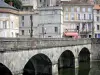
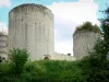
Among the other heritage elements to observe, the Pontet oven, once dedicated to pottery and which now houses a cultural space and the Levis Bridge, one of the five structures connecting the island to the rest of the world ! But there is nothing medieval behind the appellation: the bridge is metallic and dates from 1901, which does not detract from its picturesque appearance.
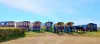
The lock and the Marais Pin dam, restored, with their "fish passage" monitored by a camera, various small ports or piers are also to be mentioned and of course the Sainte-Macrine hill with its chapel and fountain (raised in 1845).
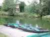
Next comes a discovery of the marshes which adjoin the courses of the Sèvre and its arms, and represent a total of 520 hectares crossed by canals.
Cultivated or even wild, bordered by greenways, these Magné marshes are classified and protected as such and their beauty and their ecological wealth are unforgettable.
Guided walks and signposted routes possibly using boats are available. Wider hikes or mountain biking also lead to Niort. Maps and information on 05 49 778 779.
It is also possible to join the outings of the local Randonneurs du Marais club: contact on +33 5 49 79 39 79. In addition, it may be useful to find out about the activities and thematic hikes regularly scheduled by the Marais Poitevin Regional Nature Park: call +33 5 49 35 15 20.
For sports, the municipal swimming pool with its outdoor pool and solarium is open from mid-June to the first week -end of September: information on +33 5 49 08 89 98. Visitors can also access a football stadium, a bowling alley, a skate park and tennis courts (bookable at +33 6 32 37 24 45).
On the cultural level, in addition to the activities offered at the media library (inquire at +33 5 49 79 63 75), we will linger at the Cultural Space of Four Pontet which hosts exhibitions throughout the year, conferences and concerts in an astonishing setting since the old two-storey oven has been preserved (information on +33 5 49 35 71 80) and on shows and exhibitions also organized at the Center socioculturel du Marais (contact +33 5 49 35 99 90).
")