Moissac-Bellevue is a commune in the Var, in the Provence-Alpes-Côte d'Azur region, 35 km north-west of Draguignan and 5 km north-west of Aups.
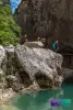
Its territory of some 20 km² ranges from 430 to 982 m altitude, in the Haut-Var, on the borders of the Alpes-de-Haute-Provence and the Verdon gorges.
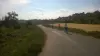
The village developed in the Middle Ages on a hill overlooking an agricultural plain bordered to the north by the Cuguyons range and to the south by the Pélenc forest (pines and holm oaks).
Moreover, forests and natural environments still cover 80% of the land in the locality…
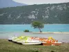
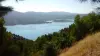
Aptly, in 1939, when the name of Moissac had existed since the 13th century, the word "Bellevue" was added to avoid confusion with the city of Tarn-et-Garonne. The fact remains that the panoramas over the Esterel, the Maures and Sainte-Baume massifs are major assets of the town, where there are nearly 300 inhabitants. Endowed with a rich heritage, with an interesting leisure offer in a preserved natural environment, Moissac-Bellevue is worth a detour near the lake of Sainte-Croix.
The village built in terraces on the top of a hill has retained all its Provencal character, dotted with paved alleys, picturesque staircases, vaulted dwellings with ocher-colored walls and roofs covered with bronze tiles (some from the 16th and 17th centuries).
Within it, as in the countryside below, the heritage is rich and varied.
A discovery walk can begin with the Saint-Sauveur church, built in the 17th century on the foundations of a Templar building. The octagonal bell tower was built in the middle of the 19th century. Nearby, the old presbytery, also from the 17th century, has been transformed into a holiday residence.
On the religious level again, a detour to the west of the village allows you to observe the chapel of Notre-Dame-de-la-Roque, which dates from the 11th and 12th centuries, and which in the Middle Ages was served by Cistercian religious. Built on a promontory, it dominates the plain (an orientation table has also been set up).
A number of oratories and crosses are also always located at crossroads and in surrounding places.
In addition to ancient remains (oppidum), on the civil level, the Clock Tower with its wrought iron bell tower was built in the center of Moissac in 1816, and one can notice in the village a number of washhouses and fountains. But the most remarkable is aptly named the Prestige fountain which dates from 1875: it then made it possible to supply the villagers with water all year round, even in summer, after the municipality bought a land with a source of ten kilometers away... The canalization work was expensive, and the town had to sell its Pélenc forest to the State!
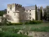
It remains to admire the castle of Moissac, in the lower part of the village, built from the end of the 16th to the beginning of the 17th, which belonged to nobility families or to merchants. A time abandoned, it was beautifully restored from the 1990s and remains in private property. As for the old seigneurial dovecote, it has also been renovated.
On the cultural side, the Polyvalent Culture and Leisure Center, which can accommodate up to 250 spectators, regularly schedules shows, and at the old town hall, exhibitions are offered throughout the year. Information on +33 4 94 70 16 21.
For athletes, a tennis court and a multi-sports ground are located on rue du Lavoir and accessible to visitors.
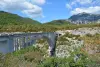
Hikers, for their part, have at their disposal a marked path, the "Pélenc circuit", dedicated to the forest which covers the lower part of the town and extends towards Aups in the south and Régusse in the north. You can walk there in the shade of pines and holm oaks. Information on +33 4 94 70 16 21. Other loops and routes can reach the Sainte-Croix lake and the Verdon gorges. Maps and information on +33 4 94 84 00 69.
It can also be very useful to contact the house of the Regional Natural Park of Verdon, of which the municipality is a member, which organizes thematic hikes, workshops, exhibitions all year round. and other activities on the environment and heritage. Join +33 4 92 74 68 00.
")