Liven up your holidays!

Ottmarsheim

Tourism, holidays & weekends guide in the Haut-Rhin

Ottmarsheim - Tourism, holidays & weekends guide in the Haut-Rhin
6.4
7

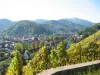
The municipality of Ottmarsheim is located south of Alsace, Mulhouse at 17 km and 7 km from the German border Neuenburg am Rhein.

The village of Ottmarsheim was born along the old Roman road linking Basel to Strasbourg.

The discovery in 1909 of a necropolis the 6th and 7th centuries proves that the area has been inhabited since the early Middle Ages.

The village was formed probably in the 8th century and it probably owes its name to St Othmar, abbot of St. Gall, who owned houses and land in nearby villages.

The first mention of the name appears in 881 Ottmarsheim in a manuscript from the Abbey of Murbach, who owned the village.

Later, the region of Ottmarsheim was the Habsburg heritage and the center of its possessions in Alsace.

Also, Rodolphe Altenburg, ancestor of this dynasty, founded there in the 11th century abbey and built an abbey between 1020 and 1040 Wonder of the Romanesque architecture, it was built on the model of the Palatine Chapel of Aix -la- Chapelle. It was consecrated in 1049 in honor of the Virgin by the Alsatian Pope Leo IX, the parent with the founder.

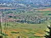
Modest and mainly agricultural village from its origin, Ottmarsheim seen between 1851 and 1941, its population gradually decline. But the story will change the lives and economy of Ottmarsheim and surrounding villages. Indeed, at the end of the First World War, the Versailles Treaty authorizes France to develop hydropower rivers. With the completion of the Grand Canal d' Alsace ( 1947), the construction of a hydroelectric power plant EDF (1948-1952 ) and the creation of the Port (1955), the second port of Alsace, develops an important industrial activity (Novartis, EDF, Pec Rhin, agricultural silo... ).

Also, a small farming village of 500 inhabitants in 1945 demographic and economic decline, its population will be multiplied by four to meet the needs of large industries that have settled in the town.

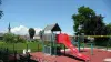
Today Ottmarsheim account in 1891 at census of 2011, which enjoy a variety of facilities and where to live. And by its community, people have a wide range of activities to exercise whether sporting or cultural.

Geographical information

MunicipalityOttmarsheim
Postcode68490
Tourism label
Latitude47.7871900 (N 47° 47’ 14”)
Longitude7.5065120 (E 7° 30’ 23”)
AltitudeFrom 217m to 235m
Surface area25.67 km²
Population2018 inhabitants
Density78 inhabitants/km²
PrefectureColmar (44 km, 33 min)
Insee code68253
IntercommunalityCA Mulhouse Alsace Agglomération
DepartmentHaut-Rhin
TerritoryAlsace
RegionGreat East

Nearest cities & towns

Hombourg3.4 km (5 min)
Bantzenheim4.8 km (6 min)
Chalampé5.9 km (8 min)
Petit-Landau7.5 km (8 min)
Rumersheim-le-Haut7.9 km (9 min)
Niffer8.9 km (9 min)
Rixheim9.7 km (13 min)
Habsheim11.3 km (15 min)
Blodelsheim11.8 km (13 min)
Kembs11.9 km (13 min)
Riedisheim12.7 km (17 min)
Munchhouse13.1 km (14 min)
Sausheim13.3 km (14 min)
Zimmersheim13.4 km (18 min)
Baldersheim13.4 km (14 min)

Things to see and do

Events and festivities

Photos

The Saint-Bernard priory, seen from the orchards (© JE)
See photo
Bell tower of the Saint-Pierre and Saint-Paul abbey church (© JE)
See photo
Abbey square (© JE)
Abbey square (© JE)
See photo
Another view of the abbey church (© JE)
See photo
Second old bell, medium, of the abbey church (© JE)
See photo
Village town hall (© JE)
See photo
Old bell, medium, of the abbey church (© JE)
See photo
Alsace resting bench (© JE)
See photo
Old large bell of the abbey church (© JE)
See photo
Chapel of the baptistery of the abbey church (© JE)
See photo
The abbey church, view from the back (© JE)
See photo
Keystone of the north chapel of the abbey church (© JE)
See photo
Keystone of the north chapel of the abbey church (© JE)
See photo
Engraved slab, in the north chapel of the abbey church (© JE)
See photo
Decorations of the organ gallery of the abbey church (© JE)
See photo
View of two elevation levels of the nave of the abbey church (© JE)
See photo
Frescoes on the ceiling of a chapel of the abbey church (© JE)
See photo
Nave of the Saint-Pierre and Saint-Paul abbey church (© JE)
See photo
Another view of the nave of the abbey church (© JE)
See photo
The choir of the abbey church (© JE)
See photo
Organ of the abbey church (© JE)
See photo
Statue of Saint Quirin, in the choir of the abbey church (© JE)
See photo
Black Madonna and Child (© JE)
See photo
Virgin and Child, in the abbey church (© JE)
See photo
Stained glass window of Saint-Pierre and Saint-Paul (© JE)
See photo
Stained glass windows of the choir of the abbey church (© JE)
See photo
The town
The town
See photo
The town
The town
See photo
The town
The town
See photo
The town
The town
See photo

Weather

Thursday 23 may
Min. 9°C - Max. 18°C
Day
Night
Friday 24 may
Min. 9°C - Max. 19°C
Day
Night
Saturday 25 may
Min. 9°C - Max. 20°C
Day
Night

Visits, leisure and activities nearby

Leisure activities

Last nameActivity typeRateCity
Museum of Wood Trades
Culture and education6 € to 8 € Labaroche (42 km)

Outings

Last nameOuting typeDifficultyDurationDeparture municipality
Hergheim Tour
HikeEasy3:00Oberhergheim (22 km)
Rangen massif
HikeIntermediate1:00Burnhaupt-le-Haut (28 km)
The Rangen massif
HikeIntermediate1:05Thann (30 km)
Eguisheim Wine-making Trail
Village visitEasy1:15Eguisheim (32 km)
Eguisheim-Hagueneck Castle-Wettolsheim
HikeIntermediate3:00Eguisheim (32 km)

Restaurants

Bed & breakfasts

Vacation rentals

Campsites

Hotels

Your holidays
A hotel
A vacation rental
A bed & breakfast
A campsite
A leisure activity
A restaurant
A rental car
A plane ticket
By continuing to browse our site, you are agreeing to the use of cookies to improve your experience and make targeted offers.
Find out more and make settings
Your account