")
- Guingamp and Notre-Dame de Bon Secours.
- Cathedral and cloister Tréguier town character.
- Côte de Granit Rose: Perros-Guirec, Trégastel, Trébeurden.
- Great Site Naturel Ploumanac'h.
- Furrow of Talbert at Armor Pleubian.
- Island of Bréhat.
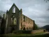
- Abbaye de Beauport.
- Radome Pleumeur-Bodou.
- Armoripark Begard.
- Forum Trégastel.
- Casino de Perros-Guirec.


Favourite