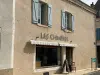

Favourite
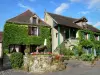
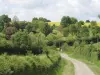
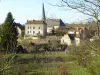
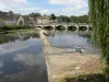
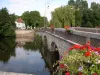
Gargilesse-Dampierre
| Municipality | Pommiers |
|---|---|
| Postcode | 36190 |
| Tourism label | ") |
| Latitude | 46.5227580 (N 46° 31’ 22”) |
| Longitude | 1.6563380 (E 1° 39’ 23”) |
| Altitude | From 196m to 280m |
| Surface area | 12.19 km² |
| Population | 215 inhabitants |
| Density | 17 inhabitants/km² |
| Prefecture | Châteauroux (40 km, 41 min) |
| Insee code | 36160 |
| Intercommunality | CC Éguzon - Argenton - Vallée de la Creuse |
| Department | Indre |
| Territory | Berry |
| Region | Centre-Loire Valley |
| Badecon-le-Pin | 6.3 km (8 min) |
|---|---|
| Chavin | 6.4 km (8 min) |
| Orsennes | 6.6 km (11 min) |
| Gargilesse-Dampierre | 6.6 km (10 min) |
| Cuzion | 7.5 km (13 min) |
| Malicornay | 9 km (12 min) |
| Montchevrier | 9 km (11 min) |
| Saint-Plantaire | 9.2 km (15 min) |
| Cluis | 9.3 km (11 min) |
| Le Menoux | 9.9 km (13 min) |
| Baraize | 11.4 km (17 min) |
| Maillet | 12 km (15 min) |
| Mouhers | 12.9 km (17 min) |
| Lourdoueix-Saint-Michel | 13.3 km (20 min) |
| Éguzon-Chantôme | 13.4 km (23 min) |
| Last name | Outing type | Difficulty | Duration | Departure municipality |
|---|---|---|---|---|
 | Car itinerary | Easy | 45 min | Saint-Sébastien (17.5 km) |
 | Hike | Easy | 3:00 | Moutier-Malcard (26 km) |
 | Hike | Easy | 2:30 | Thollet (43 km) |
 | Car itinerary | Easy | 1:00 | La Trimouille (48 km) |
 | Car itinerary | Easy | 1:00 | La Trimouille (48 km) |