Liven up your holidays!

Banks of the Isle River

Hikes & walks in Trélissac

Banks of the Isle River - Hikes & walks in Trélissac
8.2
9

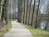
Follow the Trélissac-Périgueux-Marsac greenway which follows the banks of the Isle River by bicycle, on foot or on roller blades and enjoy the peace and quiet of some superb natural areas, discover the plant and animal life which live there, treat yourself to a glimpse of old Périgueux, in particular Saint-Front Cathedral, a major site on the Way of Saint James. Many play areas for children: several rest areas and picnic areas; a few bars and restaurants. At the end, the superb public golf area in Marsac.
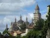
Description sheet

DepartmentDordogne
Departure municipalityTrélissac
Outing typeCycling itinerary
DifficultyEasy
Duration4:00
Recommended periodfrom january to december
EnvironmentUrban
Kilometres30 km
Altitude upon departure91m
Change in altitude70m

Access

Depart from Trélissac (park outside the church: 45,189 N; 0,759 E). Pass through the traffic lights and enter the park: make your way to the banks of the Isle River.

Itinerary

Well signposted route which follows the Isle River along its northern or southern banks or along its parallel canal. The entry and exit points are dotted all along the route and invite users to visit sites or access the various shops. Depending on your means of locomotion, by foot or on roller blades, the round trip can be adapted to the amount of time you have available. There is something for everyone and the complete round trip is 30 km long.

Examples of distances:

Trélissac picnic area: 2.4 km.

Trélissac play area: 4.2 km.

1st footbridge: 5.3 km.

Pont des Barris bridge: 6.4 km.

Pont Saint Georges bridge: 6.9 km.

Footbridge to the canal: 7.2 km.

Marsac play area: 12.1 km.

Marsac public golf course: 13.8 km.

Marsac picnic area: 15 km.

Visit ideas nearby

By continuing to browse our site, you are agreeing to the use of cookies to improve your experience and make targeted offers.
Find out more and make settings
Your account