Liven up your holidays!

Baou Saint-Jeannet

Hikes & walks in Saint-Jeannet

Baou Saint-Jeannet - Hikes & walks in Saint-Jeannet
8.9
9

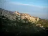
From the way Baou, about 1500 m from the village, leave the main road and turn left, a small path that winds up to the ridge line: arriving on the set, turn left to reach the top of Baou where one can enjoy breathtaking spectacle of Nice and hills, the hinterland and the chain often snowy Alps, the Esterel, the Cagne, the Var valley with Castle La Gaude, restored, and the village at his feet.

The return is possible by the same route, or a detour by the dry stone huts, going straight to the north, and recovering the GR51 to the village.

Description sheet

DepartmentAlpes-Maritimes
Departure municipalitySaint-Jeannet
Outing typeHike
DifficultyEasy
Duration2:30
Recommended periodfrom january to december
EnvironmentCountryside
Kilometres5 km
Altitude upon departure400m
Change in altitude400m

Access

From the parking René Veyssi at the village entrance, take the stairs that lead you to the Rue du Vallon and then on the place Sainte-Barbe.

Go straight into the village, and at the laundry, go right on the Place du Verger, and take the road of Bau and the path of Bau.

Itinerary

To join the Baou Saint-Jeannet, take the tag b3 GR 51 towards the Castellet.

At about 150 meters, you'll leave the GR 51 to b4 tag to direct you to the Baou Saint-Jeannet.

This is the steepest part of the course. You are now on the b5 tag and the path is moving south.

Beware, the path is a bit difficult because of its calcareous nature. We must be guided with yellow markings.

At the top, a viewpoint and a 360 ° view reward you for your efforts!

Return by the same route.

We would highly recommend you all prudent measures more if you're with children.

Visit ideas nearby

By continuing to browse our site, you are agreeing to the use of cookies to improve your experience and make targeted offers.
Find out more and make settings
Your account