•Romanesque Church of "Notre-Dame" (classified historic building, 12th century),poitevin style portal, with low-reliefs - •The "Croisée Mairand" (a site of the Wars of Vendée)
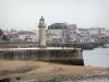
Saint-Gilles-Croix-de-Vie
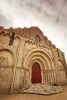
•Romanesque Church of "Notre-Dame" (classified historic building, 12th century),poitevin style portal, with low-reliefs - •The "Croisée Mairand" (a site of the Wars of Vendée)
| Department | Vendée |
|---|---|
| Departure municipality | Landevieille |
| Outing type | All-terrain bike itinerary |
| Difficulty | Intermediate |
| Duration | 50 min |
| Kilometres | 11 km |
| Altitude upon departure | 3m |
| Change in altitude | 145m |
Depart from the town of Landevieille, latitude 46.6552790 (N 46° 39’ 19”), longitude -1.7966970 (W 1° 47’ 48”)