A route to climb the highest point of the Nâves valley: the Dzonfié (2455 m).

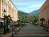
The medieval town of Conflans


A route to climb the highest point of the Nâves valley: the Dzonfié (2455 m).
| Department | Savoie |
|---|---|
| Departure municipality | La Léchère |
| Outing type | Village visit |
| Difficulty | Athletic |
| Duration | 4:00 |
| Recommended period | from may to october |
| Kilometres | 8 km |
| Altitude upon departure | 2080m |
| Change in altitude | 515m |
Departing from the spa resort of La Léchère, head towards Nâves. Go up to the Tovet car park and reach the Nant du Beurre refuge on foot. Allow 2 hours of walking each way from the Tovet plateau.
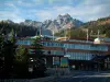
Starting from the Nant du Beurre refuge (2079 m), a beautiful route to climb the highest point of the Nâves valley: the Dzonfié (2455 m).
It can be done by trained walkers as well as active families, but is not recommended for beginner walkers or those without a minimum level of fitness due to its length and elevation. The vast majority of the route takes place through mountain pastures on open paths well exposed to the sun.
The Tour du Quermoz begins in the very typical village of Grand Nâves, the highest in the valley, at 1320 m.
At the exit of the village, the route begins with a pleasant path in the forest and on the edge interspersed with a few clearings, to reach the Raverette (1700 m). An alpine track will then take you to the Châtelard mountain (1780 m). The upper Nâves valley then opens before you. From there, the path rises through the mountain pastures to the Vieille Cave (1998 m) via the Beauregard plateau. You may be able to observe the herds of tarine cows during the summer season, or even in the distance the large herd of sheep which graze in the summer in this area. A small path on the right will take you off the track and take you to the Nant du Beurre refuge (2079 m) where you can enjoy a good meal and admire the magnificent view with the Cheval Noir, Valmorel, the Col de the Madeleine and the La Lauzière massif.
The rest of the route will take you on a small path through the mountain pastures to the Col du Vâ (2222 m) then to Quermoz (2297 m), the highest point of the route. A 360° panorama is offered to you over all the Northern Alps including Mont Blanc, Beaufortain and Vanoise.
The time to go back down will then have arrived. You will take a path in a pretty flowery valley. After passing Bozon Lake (1990 m), a forest passage will take you to Terreaux du Haut (1720 m), then to Tovet (1554 m), starting site for Nordic winter activities. A final descent will bring you back to the village of Grand Nâves.