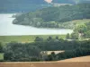

Start: picnic area above Chauffourt - Marking: green and yellow - Walking time: 3h - Duration mountain bike: 1h30 - difficult level - From the picnic area above Chauffourt, take the path that goes to the left in the wood and then, a hundred meters, turn left and follow this path to the fort of Dampierre. Watch out for the ditch! Once at the edge of the ditch, follow it on the right to the white path. Then turn left, then right, twice in a row. Then follow the "Tivières" and go beyond the paragliding site. At the next intersection, turn left and then right at the reservoir. Cross a growing area then turn left. A small paved road leads you on the D 248. From there, turn left on the departmental then right, 50 meters, to take a new paved road. A little further on, on your left, do not miss the chapel Saint-Pierre. Continue straight and turn right to take the third forest slice. Go to the forest road that you have to take, on the right, to the D 248. Then take a left and follow the departmental for two kilometers. After having left the road of the farm of Confévron aside, take a small road on the right, which crosses the oak valley, and follow it to the woods. Then turn right and follow the forest road to the end of the wood of the Mémont. Then take a left and follow the barbed wire limit to the EDF trench. At the hairpin crossroad, take the road facing you and to the left and follow it to the forest road. Turn right then, 50 meters, left and, again, left at the barrier. Continue on this forest road to the small road of the farm Oak. Turn right, past the quarry, and continue to the crossroads. There, turn right then, 100 meters, on the left to join the statue of the Virgin, its picnic area and its magnificent panorama *. Then go down slightly the hill before turning to the right to go along it until your point of departure. All the tourist info on

Nogent cutlery