From the car park, take the road to the right and go past the Salle des Fêtes.
1. Shortly after, turn left on Chemin des Béringuiers. Leave the 1st road on the right to continue straight on Chemin de Borde Naouto.
2. Continue straight on at the crossroads on chemin de Borde Neuve.
3. At the next intersection, go straight ahead, leaving the road that descends to the right and stay on the main axis (Chemin de la Forêt).
4. Carefully cross the D15 and continue straight to the end of the grassy track.
5. Turn left at its end, at the tarmac road, to follow the grassy path. At the crossroads with a white path, go straight along a water reservoir on your left. Pass Cantegril and continue to the D15.
6. Turn left to follow the road with caution, then turn right to reach the forest of Buzet, following the footpath marked in yellow. This path joins the large track that crosses the entire forest from the North car park to the South car park.
7. At the crossing of the track, follow it to the right. Once you reach the Mounjos clearing, keep left on the edge.
8. Turn left, then left again a hundred meters further, due east. Join the large straight driveway and follow it to the right to the South car park.
9. After the car park, follow the D32d to the left. Immediately after the car park on the side of the road, keep to the left at the edge of the forest on the path which allows you to avoid walking on the road.
10. Always staying on the path at the edge of the forest, follow the D32e to the left as far as the shooting range.
11. Leave the forest and cross the road to pass in front of the shooting range and follow the track that joins your starting point at the cemetery car park.
The start of the route is on a small paved road between points 1 and 2. A second paved part is between points 6 and 7. The latter can be used by cars on weekends. All the rest of the course will be on paths.
Picnic tables and toilets have been set up at the level of the car park south of the forest.
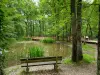
At point (6), after taking the path, a road opens up at the intersection and leads to Lac des Marcais which is all pocket, for a nice look or a short break.
Variant at (7): go straight on following the marked path to the South car park if you want to shorten the route.
Nearby, for amateurs, a permanent orienteering course has been set up in the forest. Go to the forest website for the terms and conditions.