(D / A) From the Escale car park, go north to the Dam Road (D233). Follow this road on the right for about 300 m.
(1) Take the path on the left, Blue markup.
(2) Take the road for a few meters before finding the path on the left.
(3) Cross EDF dams, paying attention to cars, narrow passage.
(4) Leave the road and go to the edge of the lake on the right.
(5) At the junction with a small road, take the path on the left.
(6) At Auchaize, take the path on the right at the exit of the village. Then, at each junction, take the right path.
(7) Find the road and follow it to the left.
(8) After about 400 m, leave the road and follow the path on the right. At the next intersection, turn left. After about 250 m, at an intersection, turn right. At the next intersection, turn right.
(9) To follow the path of banks, take the path on your left.
(10) At a fork, continue straight on the path. Get closer to the road and stay roughly parallel to it.
(11) Return to the edge of the lake and follow it on your right. Take a dike and join the road.
(12) Follow the road on the right for about 200 m. Before the roundabout, take the path on the right. Walk between the shore and the D3 road.
(13) Take the bridge and continue along the shore. Then cross the village of Broussas.
(14) At the intersection (holiday village on the right), continue straight.
(15) At the fork, continue straight to enjoy the beautiful view of Broussas beach.
(16) Turn left, follow the beach and take the road back to the campsite.
(15) Retrace your steps to the holiday village.
(14) Take the path to the right and turn right. Cross the Maulde River and find the shore of the lake. Walk along the lake and pass a campsite and a recreation center.
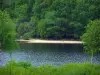
(17) Get off in direct access from Nergout beach. Supervised swimming in summer, for this white sand beach. Take the marked path in blue on the left. Walk along the banks. Discover the port of Nergout, then go up to the road.
(18) Follow the road on the right (short 1 km).
(19) After Châteaucourt, take the path on your right which brings you back to the lake shore. Follow the path by the lake, and enjoy several points of view. In summer, to observe the elder trees, with which, is realized the jelly of wild berries.
(20) Resume the road on the right until the next fork.
(21) At the fork, turn right on the road to the peninsula of Pierrefite, and Vassivière Island. Cross a small road and turn left on the road previously left.
(22) Follow the path along the lake, pass Port Crozat and reach the beach of Auphelle.
(23) Find the road to go up to the parking of the restaurant l'Escale.