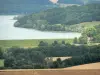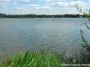
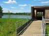

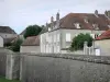
Departure: parking of the beach - Signposting: blue and yellow - Duration on foot: 1h30 - Duration in VTT: 45 min - easy level - To take the direction of the North by following the beach, to pass the zone of launching of the boats for fishing to join the ornithological observatory. After this first observation, take the path along the D 128, cross the bridge then turn left to cross the bay of Percey and reach the village. In the latter, take the small road on your left, pass the picnic area and turn left again to take a path grass you follow until the National 74. Cross it taking care to traffic. Follow the path in front for about ten meters before turning right then left. Then cross the wood to reach a small asphalt road. Go over the Vingeanne and continue to the crossroads with the D 141 (cross road). There, turn left again and take a grass path that runs along the wood on one side and the fields on the other. Arriving at "Pré Grillon", continue straight on a white path that will lead you to the N 74. Cross again and continue on the white path at the edge of the fields. At a place called "les étaules", stay between the houses and the lake to join the water tower. There, take the grass path on the dam to join the nautical base and your starting point. All the tourist info on
Langres