

Departure: Parking Auberive Country House - Markings: green and yellow - Walking time: 2h30 - Duration mountain bike: 1h30 - Difficult level - From the place of the house of the Country of Auberive, take the GR7 (markup white and red) on the D 428, towards Bay-sur-Aube. Just after the pond Auberive, turn left and follow the D 150 towards Villars-Santenoge. After 1 km, continue straight ahead to join the forest house of Val Clavin. There, continue always straight while staying on the GR7 until the climb in the forest of Montgérand. From here, leave the GR (on the left) and continue climbing up the right path. You then join a slice straight you must follow until the D 150. Turn left and follow the departmental until the next intersection, a hundred meters. There, leave the D 150 to take on your right the small road which leads you in the valley of the Germainelle and the Farm of Amorey. At the junction with the road to the farm, turn right, then 500 m right again to follow the valley on the edge of the forest of the Grande Montagne. After one kilometer, the Tufière d'Amorey is revealed at the turn of a bend in the forest path. Continue straight to the forest house and continue on this path until the crossroads of 5 paths. There, take a right on the path that passes over the Germainelle by a footbridge of logs. Continue on your right and take the slice that goes to the right. After a hundred meters, leave this slice to follow the small path that climbs faster on the heights of wood Cellerons. Continue then on the edge which goes along this wood until the crossroads of the 7 ways of Montgérand. There, leave the forest road on the side to take the left path that is the angle. Then continue on the path that brings you back to Auberive, with a nice view of the village. Back on the D 428, turn left, then right at the Lion d'Or to gain the walk between the two waters, and from there your starting point. All the tourist info on

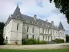
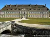
Auberive Abbey