Pleasant and well shaded forest itinerary dominating the hamlet of Uzéfaing.
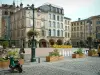
Épinal
Pleasant and well shaded forest itinerary dominating the hamlet of Uzéfaing.

| Department | Vosges |
|---|---|
| Departure municipality | Épinal |
| Outing type | Hike |
| Difficulty | Easy |
| Duration | 3:00 |
| Recommended period | from april to october |
| Environment | Countryside |
| Kilometres | 8 km |
| Change in altitude | 175m |
From Épinal, follow signs to Gérardmer via the D11 for 4 km. At Tranchée de Docelles, take a small road on the right called Chemin d'Uzéfaing. This small road, which enters the forest, leads you to the hamlet of Uzéfaing. On the way out of the hamlet, just after crossing the stream, there is a wooden shelter on the right which is the start of the circuit.
Opposite the shelter (car park), cross the tarmac road and take the stone path towards the forest. At its entrance, after crossing a gate, the path turns right and climbs up a gentle slope signposted with a yellow diamond.
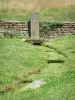
At the top of the hill, a short detour (100 m off of the trail) leads to a viewpoint (1) over Moselle and the hamlet of Soba. Return to the itinerary and take the path on the right. After a 150 m climb, you will cross a forest trail. Continue along this path to a small clearing where a stone path ends. Follow this ridge path for more than 2 km and after passing under the power line, you will arrive at a crossroads of four paths, at the centre of which stands a spruce tree. Near this junction, you will find a picnic table (2).
Turn left on to the Grande Chêneau stone path and after 600 m, turn left on to a grassy forest trail. 600 m further on, it arrives at the stone path. Do not leave the forest, but turn left on to a path down the slope which runs along the valley. After passing the information board (3) presenting the hydrographic network of the Tranchée de Docelles stream, you will arrive at a tarmac road after crossing a small aqueduct over the stream. Turn left on to the road and follow it for 40 m, and then turn right and follow the path straight ahead after passing another information board. Follow this path for 250 m and then turn left on to a grassy forest trail. Keeping to the left, the path leads to a forest road. Turn left and make your way to a crossroads and follow the road on the right which leads to a turning place. Continue the itinerary along a small dirt track on the left. Follow the "Circuit d'Uzéfaing" signposting and leave the ridge path and pass near two panoramic viewpoints over the Rosé valley and the hamlet of Uzéfaing. At the second panoramic viewpoint (4), walk down a small winding path through the ferns and turn left on to a trail. You will arrive on the path which descends from the ridge and turn right on to it (yellow diamond) to the road leading to the hamlet of Uzéfaing. Turn right, pass through the hamlet and return to where you started out.