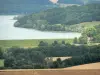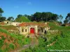


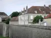
Departure: Hûmes camping place - Signposting: yellow and yellow - Walking time: 5h - Duration mountain bike: 2h30 - Difficult level - From the Hûmes campsite, take the direction of Saint-Ciergues on the D 286. At the exit from the village, just after the St-Vinebault fountain, turn right to take a white path that leads to Melville. Go past the castle and turn right again in front of the equestrian center. one kilometer on this path before turning left along a grass path. In the small wood, turn left and follow the path to the top of "Roche Tantisbé". Once at the top, turn right to follow the wood, at the junction turn left to reach Saint-Martin-lès-Langres. From here, turn left and continue to the church where you will find a first picnic area with a magnificent panorama of the lake of the Fly. Then go down the small road until the D 286. Turn left then immediately right, and continue down to the river following the road. After the mill, turn right on a path leading to the foot of the dam. Turn right to join Saint-Ciergues. In the village turn right and follow the D 286 for 250 meters before turning on the left. Go to the church and go down the small path lined with a stone wall. Turn left, cross the square and continue down to the dam. Cross it and turn right to continue along the lake for one kilometer. At the parking, take the path that climbs to the left and engage in the wood. Cross it all the way to get to Perrancey-les-Vieux-Moulins. Arrived at the center of the village, turn left to take the GR 7 passing near the laundry. Continue climbing up to the D 135 that you have to cross. At the next crossroads, take a path on the left that will take you to strategic n ° 6 across the fields. Turn left, past the Arbelotte farm, take the road on the right then the white road, on the right again. This last one makes you pass in front of the fort of the Pointe de Diamant and near the battery of Hûmes which deserves a small return to its picnic area. At the junction with the battery road, turn right to reach Hûmes and your starting point, bypassing the campsite by the small path provided for this purpose. All the tourist info on
Langres