

Favourite
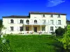
The Château of La Rochefoucauld
| Municipality | Agris |
|---|---|
| Postcode | 16110 |
| Latitude | 45.7753840 (N 45° 46’ 31”) |
| Longitude | 0.3355830 (E 0° 20’ 8”) |
| Altitude | From 70m to 134m |
| Surface area | 18.74 km² |
| Population | 869 inhabitants |
| Density | 46 inhabitants/km² |
| Prefecture | Angoulême (23 km, 27 min) |
| Insee code | 16003 |
| Intercommunality | CC La Rochefoucauld porte du Périgord |
| Department | Charente |
| Territory | Charentes |
| Region | New-Aquitaine |
| Rivières | 3.3 km (5 min) |
|---|---|
| La Rochette | 3.5 km (5 min) |
| Coulgens | 5.9 km (8 min) |
| Jauldes | 7.3 km (10 min) |
| Taponnat-Fleurignac | 8.9 km (11 min) |
| La Rochefoucauld-en-Angoumois | 9 km (12 min) |
| Les Pins | 9.2 km (12 min) |
| Brie | 10 km (14 min) |
| Saint-Mary | 10.1 km (14 min) |
| Val-de-Bonnieure | 10.6 km (12 min) |
| Anais | 11.3 km (12 min) |
| Marillac-le-Franc | 11.9 km (15 min) |
| Chasseneuil-sur-Bonnieure | 12.2 km (13 min) |
| La Tâche | 13.3 km (19 min) |
| Last name | Activity type | Rate | City |
|---|---|---|---|
 | Entertainment | 52 € to 84 € | La Rochefoucauld-en-Angoumois (5.3 km) |
 | Local flavours | Free | Graves-Saint-Amant (36 km) |
| Last name | Outing type | Difficulty | Duration | Departure municipality |
|---|---|---|---|---|
 | Village visit | Easy | 1:30 | Bunzac (8.4 km) |
 | Hike | Easy | 1:30 | Eymouthiers (22 km) |
| Hike | Easy | 1:00 | Mons (29 km) |
 | Hike | Easy | 4:00 | Saint-Estèphe (33 km) |
 | Hike | Easy | 2:30 | Vendoire (40 km) |