


Favourite
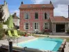
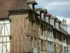
Troyes
| Municipality | Buchères |
|---|---|
| Postcode | 10800 |
| Tourism label | ") |
| Latitude | 48.2356900 (N 48° 14’ 8”) |
| Longitude | 4.1126360 (E 4° 6’ 45”) |
| Surface area | 7.14 km² |
| Population | 1918 inhabitants |
| Density | 268 inhabitants/km² |
| Prefecture | Troyes (8.2 km, 14 min) |
| Insee code | 10067 |
| Intercommunality | CA Troyes Champagne Métropole |
| Department | Aube |
| Territory | Champagne-Ardenne |
| Region | Great East |
| Bréviandes | 2.9 km (5 min) |
|---|---|
| Verrières | 3.1 km (6 min) |
| Saint-Léger-près-Troyes | 3.2 km (6 min) |
| Isle-Aumont | 3.6 km (6 min) |
| Moussey | 3.9 km (6 min) |
| Saint-Julien-les-Villas | 4.8 km (7 min) |
| Saint-Thibault | 4.9 km (8 min) |
| Rosières-près-Troyes | 6.4 km (11 min) |
| Villemereuil | 6.5 km (8 min) |
| Saint-Pouange | 6.6 km (10 min) |
| Les Bordes-Aumont | 6.6 km (8 min) |
| Montaulin | 7.6 km (12 min) |
| Saint-André-les-Vergers | 7.7 km (13 min) |
| Troyes | 7.9 km (15 min) |
| Last name | Activity type | Rate | City |
|---|---|---|---|
 | Entertainment | 30 € to 40 € | Ville-sur-Arce (29 km) |
| Last name | Outing type | Difficulty | Duration | Departure municipality |
|---|---|---|---|---|
 | Hike | Easy | 2:10 | Troyes (7.2 km) |
 | Hike | Easy | 50 min | Troyes (7.4 km) |
 | All-terrain bike itinerary | Easy | 3:30 | Bouilly (9.7 km) |
 | Hike | Easy | 4:45 | Sommeval (13.5 km) |
 | Hike | Easy | 1:55 | Lusigny-sur-Barse (14.1 km) |