


Favourite
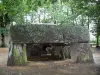
Roche-aux-Fées
| Municipality | Erbray |
|---|---|
| Postcode | 44110 |
| Tourism label | ") |
| Latitude | 47.6545040 (N 47° 39’ 16”) |
| Longitude | -1.3177750 (W 1° 19’ 4”) |
| Altitude | From 41m to 108m |
| Surface area | 58.18 km² |
| Population | 3116 inhabitants |
| Density | 53 inhabitants/km² |
| Prefecture | Nantes (73 km, 1:07) |
| Insee code | 44054 |
| Intercommunality | CC Châteaubriant-Derval |
| Department | Loire-Atlantique |
| Region | Pays de la Loire |
| Petit-Auverné | 5.5 km (9 min) |
|---|---|
| Saint-Julien-de-Vouvantes | 6.1 km (8 min) |
| Moisdon-la-Rivière | 6.5 km (10 min) |
| Grand-Auverné | 7.5 km (8 min) |
| Louisfert | 9.8 km (15 min) |
| Châteaubriant | 9.8 km (15 min) |
| La Chapelle-Glain | 10.2 km (12 min) |
| Soudan | 10.3 km (14 min) |
| Issé | 12.4 km (16 min) |
| Juigné-des-Moutiers | 13.1 km (17 min) |
| La Meilleraye-de-Bretagne | 14.1 km (14 min) |
| Noyal-sur-Brutz | 15.7 km (17 min) |
| Le Pin | 15.7 km (19 min) |
| Riaillé | 16.5 km (17 min) |
| Leisure centres |
|---|
| Last name | Outing type | Difficulty | Duration | Departure municipality |
|---|---|---|---|---|
 | Cycling itinerary | Easy | 1:15 | Rougé (17.5 km) |
 | Hike | Easy | 2:05 | Oudon (34 km) |
 | Hike | Intermediate | 3:00 | Piré-Chancé (40 km) |
 | All-terrain bike itinerary | Easy | 1:20 | Ingrandes-Le Fresne sur Loire (41 km) |
 | Cycling itinerary | Easy | 5:00 | Carquefou (42 km) |