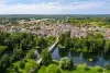
With a population of 1,751 inhabitants on 973 hectares, the geographical location is quite particular because the commune of Fontenay-sur-Loing extends over 8 km in length and 1.5 km at its widest. It’s a bit like the Chili of Gâtinais.
Its limits are the Cléry river to the north, the Loing to the west, the Montargis forest to the south and local roads to the east.
It is crossed from north to south by the Departmental road 2007 (ex Nationale 7) managed by the General Council of Loiret.
The Paris - Nevers railway line also crosses the entire length of the commune, as well as the Loing canal.
The A 19 motorway made its appearance in the landscape of the commune with its opening on June 16, 2009. The interchange with the RD 2007 allows travel to the East or West of France much faster and secure.
Fontenay-sur-Loing is part of the canton of Courtenay which includes 19 municipalities. These are grouped within the CC4V, Community of Communes of the 4 Vallées.
Fontenay owes its name to the Latin name "fons" "fontis", which means "the source", which will become Fontenoy over time and finally Fontenay, thanks to the St Victorin spring still present in the territory, which healed fevers, swelling, languor and which were said to be specific to make gravel and stones (kidney stones) disappear.
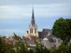
With the arrival of the railway in 1860, the topography of the village was disrupted. The church, in the middle of the cemetery, was located on the route of the SNCF line and was demolished without changing the course of the source, which still gives rise to a small stream, feeding the village mill before flowing into the Loing.
")