


Favourite
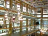
La Grande Place, Saint-Louis Crystal Museum
| Municipality | Herbitzheim |
|---|---|
| Postcode | 67260 |
| Latitude | 49.0168490 (N 49° 1’ 1”) |
| Longitude | 7.0827940 (E 7° 4’ 58”) |
| Altitude | From 203m to 282m |
| Surface area | 21.73 km² |
| Population | 1866 inhabitants |
| Density | 85 inhabitants/km² |
| Prefecture | Strasbourg (91 km, 1:02) |
| Insee code | 67191 |
| Intercommunality | CC de l'Alsace Bossue |
| Department | Bas-Rhin |
| Territory | Alsace |
| Region | Great East |
| Oermingen | 4.2 km (6 min) |
|---|---|
| Willerwald | 4.3 km (9 min) |
| Sarralbe | 5 km (8 min) |
| Siltzheim | 5.9 km (7 min) |
| Keskastel | 6.5 km (8 min) |
| Wittring | 7.2 km (11 min) |
| Kalhausen | 7.3 km (10 min) |
| Neufgrange | 8.7 km (10 min) |
| Etting | 9.1 km (14 min) |
| Voellerdingen | 9.1 km (11 min) |
| Zetting | 9.5 km (16 min) |
| Rémelfing | 9.5 km (11 min) |
| Schopperten | 9.5 km (13 min) |
| Achen | 10 km (14 min) |
| Transport |
|---|
| Last name | Activity type | Rate | City |
|---|---|---|---|
 | Sports sensations | 15 € to 32 € | Niederbronn-les-Bains (42 km) |
| Last name | Outing type | Difficulty | Duration | Departure municipality |
|---|---|---|---|---|
 | Cycling itinerary | Easy | 4:00 | Lorentzen (9.9 km) |
| Hike | Easy | 2:00 | Diemeringen (11.4 km) |
| Cycling itinerary | Easy | 4:30 | Frauenberg (13.7 km) |
 | Hike | Athletic | 4:20 | Zittersheim (23 km) |
 | Hike | Athletic | 2:50 | Wingen-sur-Moder (24 km) |